Pie de la Cuesta geodata
Pie de la Cuesta (Veracruz) is a populated place; located in Mexico in America/Mexico_City (GMT-6) time zone. With population of 882 people, there are 9904 cities with bigger population in this country. Compared to other cities in Mexico, 70.2% of cities are located further ↓South; 59.1% of cities are located further ←West and 50.4% of cities have lower elevation than Pie de la Cuesta. Note1


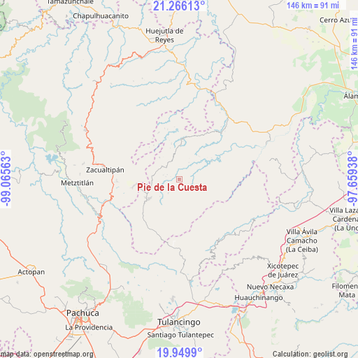
Pie de la Cuesta GPS coordinates[2]
20° 36' 33.984" North, 98° 21' 45" West
| Map corner | latitude | longitude |
|---|---|---|
| Upper-left | 21.26613°, | -99.06563° |
| Center: | 20.60944°, | -98.3625° |
| Lower-right: | 19.9499°, | -97.65938° |
| Map W x H: | 146.4×146.4 km | = 91×91mi |
| max Lat: | 32.7° ⇑29.8% North |
| Pie de la Cuesta: | 20.60944° |
| min Lat: | ⇓70.2% South 14.53588° |
| min Long | Pie de la Cuest | max Long |
| -117.105° | -98.3625° | -86.73105° |
| W 59.1%⇐ | ⇒40.9% E |
Elevation
Elevation of Pie de la Cuesta is 1454 m = 4770 ft, and this is 200.3 m = 657 ft above average elevation for this country.
| Max E: |
3497 m = 11473 ft | 49.6% |
| Pie de la Cuesta | 1454 m 4770 ft | |
| Avg. | 1253.7 m = 4113 ft | |
Min E: |
-1 m = -3 ft | 50.4% |
See also: Mexico elevation on elevation.city.
Geographical zone
Pie de la Cuesta is located in North Torrid zone (between Equator and Tropic of Cancer). Distance of this Northern Tropic circle is 314.4 km =195.4 mi to North.| Distance of | km | miles | from Pie de la Cuesta |
|---|---|---|---|
| North Pole | 7715.5 | 4794.2 | to North |
| Arctic Circle | 5109.6 | 3175 | to North |
| Tropic Cancer | 314.4 | 195.4 | to North |
| Equator | 2291.6 | 1423.9 | to South |


Nearby cities:
15 places around Pie de la Cuesta: (largest is in red/bold)
• Atempa
17.1 km =10.6 mi,  341°
341°
• Ayotuxtla
7.6 km =4.7 mi,  54°
54°
• El Pericón
11.9 km =7.4 mi,  71°
71°
• Huayacocotla
14.7 km =9.1 mi,  236°
236°
• José María Pino Suárez
14.9 km =9.3 mi,  347°
347°
• La Florida
3 km =1.9 mi,  123°
123°
• La Mirra
2.3 km =1.4 mi,  32°
32°
• La Selva
15.6 km =9.7 mi,  252°
252°
• Las Canoas
2.1 km =1.3 mi,  140°
140°
• Texcatepec
2.7 km =1.7 mi,  186°
186°
• Tlachichilco
17.1 km =10.6 mi,  85°
85°
• Tzicatlán
15 km =9.3 mi,  61°
61°
• Zilacatipan
8.8 km =5.5 mi,  306°
306°
• Zontecomatlán de López y Fuentes
17.1 km =10.6 mi,  6°
6°
• Zonzonapa
12 km =7.5 mi,  317°
317°
Sources, notices
• [Note1] Compared only with cities in Mexico existing in our database
• [Src1] Map data: © OpenStreetMap contributors (CC-BY-SA)
• [Src2] Other city data from geonames.org with taken over terms of usage.
• [Src3] Geographical zone / Annual Mean Temperature by Robert A. Rohde @ Wikipedia
