La Selva geodata
La Selva (Hidalgo) is a populated place; located in Mexico in America/Mexico_City (GMT-6) time zone. With population of 533 people, there are 15888 cities with bigger population in this country. Compared to other cities in Mexico, 69.3% of cities are located further ↓South; 57.2% of cities are located further ←West and 74.2% of cities have lower elevation than La Selva. Note1


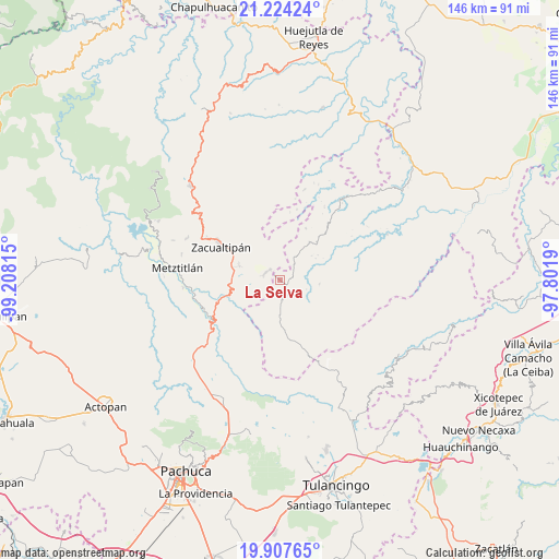
La Selva GPS coordinates[2]
20° 34' 2.496" North, 98° 30' 18.072" West
| Map corner | latitude | longitude |
|---|---|---|
| Upper-left | 21.22424°, | -99.20815° |
| Center: | 20.56736°, | -98.50502° |
| Lower-right: | 19.90765°, | -97.8019° |
| Map W x H: | 146.4×146.4 km | = 91×91mi |
| max Lat: | 32.7° ⇑30.7% North |
| La Selva: | 20.56736° |
| min Lat: | ⇓69.3% South 14.53588° |
| min Long | La Selva | max Long |
| -117.105° | -98.50502° | -86.73105° |
| W 57.2%⇐ | ⇒42.8% E |
Elevation
Elevation of La Selva is 2016 m = 6614 ft, and this is 762.3 m = 2501 ft above average elevation for this country.
| Max E: |
3497 m = 11473 ft | 25.8% |
| La Selva | 2016 m 6614 ft | |
| Avg. | 1253.7 m = 4113 ft | |
Min E: |
-1 m = -3 ft | 74.2% |
See also: Mexico elevation on elevation.city.
Geographical zone
La Selva is located in North Torrid zone (between Equator and Tropic of Cancer). Distance of this Northern Tropic circle is 319 km =198.2 mi to North.| Distance of | km | miles | from La Selva |
|---|---|---|---|
| North Pole | 7720.2 | 4797.1 | to North |
| Arctic Circle | 5114.3 | 3177.9 | to North |
| Tropic Cancer | 319 | 198.2 | to North |
| Equator | 2286.9 | 1421 | to South |


Nearby cities:
15 places around La Selva: (largest is in red/bold)
• Atecoxco
10.9 km =6.8 mi,  232°
232°
• Atopixco
11.3 km =7 mi,  289°
289°
• Carpinteros
4.2 km =2.6 mi,  299°
299°
• Huayacocotla
4.2 km =2.6 mi,  143°
143°
• Jalapa
11.8 km =7.3 mi,  354°
354°
• La Mojonera
13.7 km =8.5 mi, 298°
• Mezquititlán
14.3 km =8.9 mi,  254°
254°
• Palo Bendito
12.3 km =7.6 mi,  177°
177°
• Texcatepec
14.7 km =9.1 mi,  82°
82°
• Tizapán
13.4 km =8.3 mi,  314°
314°
• Tlahuelompa (San Francisco Tlahuelompa)
11.8 km =7.3 mi,  321°
321°
• Tuzanapa
8.3 km =5.2 mi,  279°
279°
• Xoxoteco
13.8 km =8.6 mi, 245°
• Zilacatipan
12.6 km =7.8 mi,  38°
38°
• Zonzonapa
15.1 km =9.4 mi,  26°
26°
Sources, notices
• [Note1] Compared only with cities in Mexico existing in our database
• [Src1] Map data: © OpenStreetMap contributors (CC-BY-SA)
• [Src2] Other city data from geonames.org with taken over terms of usage.
• [Src3] Geographical zone / Annual Mean Temperature by Robert A. Rohde @ Wikipedia
