Zilacatipan geodata
Zilacatipan (Veracruz) is a populated place; located in Mexico in America/Mexico_City (GMT-6) time zone. With population of 543 people, there are 15651 cities with bigger population in this country. Compared to other cities in Mexico, 71% of cities are located further ↓South; 58.2% of cities are located further ←West and 63.3% of cities have lower elevation than Zilacatipan. Note1


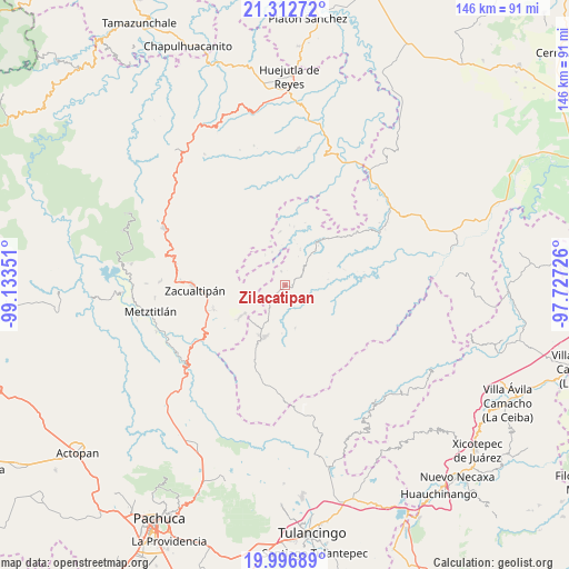
Zilacatipan GPS coordinates[2]
20° 39' 22.428" North, 98° 25' 49.368" West
| Map corner | latitude | longitude |
|---|---|---|
| Upper-left | 21.31272°, | -99.13351° |
| Center: | 20.65623°, | -98.43038° |
| Lower-right: | 19.99689°, | -97.72726° |
| Map W x H: | 146.3×146.3 km | = 90.9×90.9mi |
| max Lat: | 32.7° ⇑29% North |
| Zilacatipan: | 20.65623° |
| min Lat: | ⇓71% South 14.53588° |
| min Long | Zilacatipan | max Long |
| -117.105° | -98.43038° | -86.73105° |
| W 58.2%⇐ | ⇒41.8% E |
Elevation
Elevation of Zilacatipan is 1783 m = 5850 ft, and this is 529.3 m = 1737 ft above average elevation for this country.
| Max E: |
3497 m = 11473 ft | 36.7% |
| Zilacatipan | 1783 m 5850 ft | |
| Avg. | 1253.7 m = 4113 ft | |
Min E: |
-1 m = -3 ft | 63.3% |
See also: Mexico elevation on elevation.city.
Geographical zone
Zilacatipan is located in North Torrid zone (between Equator and Tropic of Cancer). Distance of this Northern Tropic circle is 309.2 km =192.1 mi to North.| Distance of | km | miles | from Zilacatipan |
|---|---|---|---|
| North Pole | 7710.3 | 4791 | to North |
| Arctic Circle | 5104.4 | 3171.7 | to North |
| Tropic Cancer | 309.2 | 192.1 | to North |
| Equator | 2296.8 | 1427.2 | to South |


Nearby cities:
15 places around Zilacatipan: (largest is in red/bold)
• Apachitla
9.3 km =5.8 mi,  326°
326°
• Atempa
11.1 km =6.9 mi,  7°
7°
• Ayotuxtla
13.3 km =8.3 mi,  93°
93°
• Carpinteros
13.8 km =8.6 mi,  235°
235°
• Jalapa
9.1 km =5.7 mi,  281°
281°
• José María Pino Suárez
10 km =6.2 mi,  22°
22°
• La Florida
11.8 km =7.3 mi,  125°
125°
• La Mirra
8.9 km =5.5 mi,  111°
111°
• La Selva
12.6 km =7.8 mi,  218°
218°
• Las Canoas
10.8 km =6.7 mi, 129°
• Pie de la Cuesta
8.8 km =5.5 mi, 126°
• San Pablo Mitecatlán
11.1 km =6.9 mi,  300°
300°
• Tecapa
9.2 km =5.7 mi,  338°
338°
• Texcatepec
10.4 km =6.5 mi,  139°
139°
• Zonzonapa
3.8 km =2.4 mi, 344°
Sources, notices
• [Note1] Compared only with cities in Mexico existing in our database
• [Src1] Map data: © OpenStreetMap contributors (CC-BY-SA)
• [Src2] Other city data from geonames.org with taken over terms of usage.
• [Src3] Geographical zone / Annual Mean Temperature by Robert A. Rohde @ Wikipedia
