Huayacocotla geodata
Huayacocotla (Veracruz) is a seat of a second-order administrative division; located in Mexico in America/Mexico_City (GMT-6) time zone. With population of 5,211 people, there are 1774 cities with bigger population in this country. Compared to other cities in Mexico, 68.6% of cities are located further ↓South; 57.5% of cities are located further ←West and 81.2% of cities have lower elevation than Huayacocotla. Note1


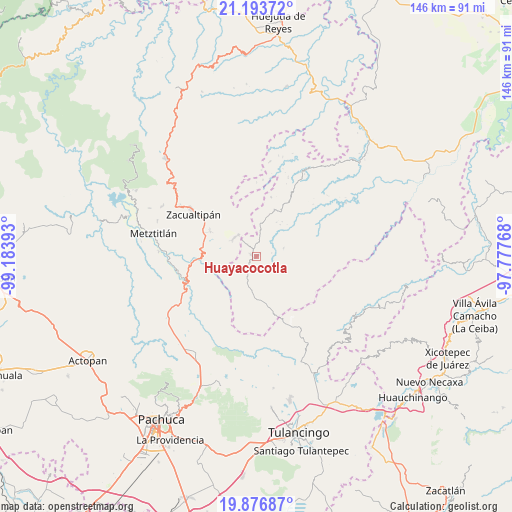
Huayacocotla GPS coordinates[2]
20° 32' 12.156" North, 98° 28' 50.88" West
| Map corner | latitude | longitude |
|---|---|---|
| Upper-left | 21.19372°, | -99.18393° |
| Center: | 20.53671°, | -98.4808° |
| Lower-right: | 19.87687°, | -97.77768° |
| Map W x H: | 146.4×146.4 km | = 91×91mi |
| max Lat: | 32.7° ⇑31.4% North |
| Huayacocotla: | 20.53671° |
| min Lat: | ⇓68.6% South 14.53588° |
| min Long | Huayacocotla | max Long |
| -117.105° | -98.4808° | -86.73105° |
| W 57.5%⇐ | ⇒42.5% E |
Elevation
Elevation of Huayacocotla is 2169 m = 7116 ft, and this is 915.3 m = 3003 ft above average elevation for this country.
| Max E: |
3497 m = 11473 ft | 18.8% |
| Huayacocotla | 2169 m 7116 ft | |
| Avg. | 1253.7 m = 4113 ft | |
Min E: |
-1 m = -3 ft | 81.2% |
See also: Mexico elevation on elevation.city.
Geographical zone
Huayacocotla is located in North Torrid zone (between Equator and Tropic of Cancer). Distance of this Northern Tropic circle is 322.5 km =200.4 mi to North.| Distance of | km | miles | from Huayacocotla |
|---|---|---|---|
| North Pole | 7723.6 | 4799.2 | to North |
| Arctic Circle | 5117.7 | 3180 | to North |
| Tropic Cancer | 322.5 | 200.4 | to North |
| Equator | 2283.5 | 1418.9 | to South |


Nearby cities:
15 places around Huayacocotla: (largest is in red/bold)
• Atecoxco
11.6 km =7.2 mi,  254°
254°
• Atopixco
15 km =9.3 mi,  298°
298°
• Carbonero Jacales
12.9 km =8 mi,  175°
175°
• Carpinteros
8.2 km =5.1 mi,  311°
311°
• Jalapa
15.6 km =9.7 mi,  346°
346°
• La Selva
4.2 km =2.6 mi,  323°
323°
• Las Canoas
15.1 km =9.4 mi,  64°
64°
• Palo Bendito
9.1 km =5.7 mi,  192°
192°
• Palo Hueco
11.3 km =7 mi,  166°
166°
• Pie de la Cuesta
14.7 km =9.1 mi, 56°
• Texcatepec
13.2 km =8.2 mi,  65°
65°
• Teximalpa
14.3 km =8.9 mi, 194°
• Tuzanapa
11.7 km =7.3 mi,  293°
293°
• Xoxoteco
15.2 km =9.4 mi,  260°
260°
• Zilacatipan
14.3 km =8.9 mi,  21°
21°
Sources, notices
• [Note1] Compared only with cities in Mexico existing in our database
• [Src1] Map data: © OpenStreetMap contributors (CC-BY-SA)
• [Src2] Other city data from geonames.org with taken over terms of usage.
• [Src3] Geographical zone / Annual Mean Temperature by Robert A. Rohde @ Wikipedia
