Zonzonapa geodata
Zonzonapa (Veracruz) is a populated place; located in Mexico in America/Mexico_City (GMT-6) time zone. With population of 746 people, there are 11739 cities with bigger population in this country. Compared to other cities in Mexico, 71.5% of cities are located further ↓South; 58.1% of cities are located further ←West and 52% of cities have higher elevation than Zonzonapa. Note1


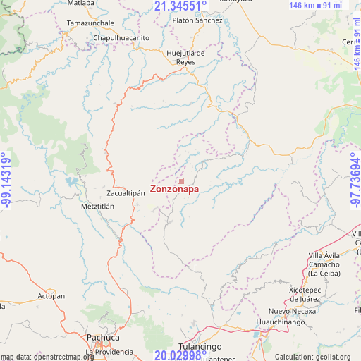
Zonzonapa GPS coordinates[2]
20° 41' 21.012" North, 98° 26' 24.216" West
| Map corner | latitude | longitude |
|---|---|---|
| Upper-left | 21.34551°, | -99.14319° |
| Center: | 20.68917°, | -98.44006° |
| Lower-right: | 20.02998°, | -97.73694° |
| Map W x H: | 146.3×146.3 km | = 90.9×90.9mi |
| max Lat: | 32.7° ⇑28.5% North |
| Zonzonapa: | 20.68917° |
| min Lat: | ⇓71.5% South 14.53588° |
| min Long | Zonzonapa | max Long |
| -117.105° | -98.44006° | -86.73105° |
| W 58.1%⇐ | ⇒41.9% E |
Elevation
Elevation of Zonzonapa is 1339 m = 4393 ft, and this is 85.3 m = 280 ft above average elevation for this country.
| Max E: |
3497 m = 11473 ft | 52% |
| Zonzonapa | 1339 m 4393 ft | |
| Avg. | 1253.7 m = 4113 ft | |
Min E: |
-1 m = -3 ft | 48% |
See also: Mexico elevation on elevation.city.
Geographical zone
Zonzonapa is located in North Torrid zone (between Equator and Tropic of Cancer). Distance of this Northern Tropic circle is 305.5 km =189.8 mi to North.| Distance of | km | miles | from Zonzonapa |
|---|---|---|---|
| North Pole | 7706.6 | 4788.7 | to North |
| Arctic Circle | 5100.8 | 3169.5 | to North |
| Tropic Cancer | 305.5 | 189.8 | to North |
| Equator | 2300.4 | 1429.4 | to South |


Nearby cities:
15 places around Zonzonapa: (largest is in red/bold)
• Apachitla
5.8 km =3.6 mi,  315°
315°
• Arnatepec
12 km =7.5 mi,  16°
16°
• Atempa
7.8 km =4.8 mi, 18°
• Chahuatlán
11.5 km =7.1 mi, 24°
• Ilamatlán
10.2 km =6.3 mi,  358°
358°
• Ixcotitlán
12 km =7.5 mi,  308°
308°
• Jalapa
8.1 km =5 mi,  257°
257°
• José María Pino Suárez
7.4 km =4.6 mi,  40°
40°
• La Mirra
11.6 km =7.2 mi,  126°
126°
• Pie de la Cuesta
12 km =7.5 mi,  137°
137°
• Polintotla
10.9 km =6.8 mi, 320°
• San Pablo Mitecatlán
8.7 km =5.4 mi,  283°
283°
• Santa Cruz
12.1 km =7.5 mi,  10°
10°
• Tecapa
5.5 km =3.4 mi,  334°
334°
• Zilacatipan
3.8 km =2.4 mi,  164°
164°
Sources, notices
• [Note1] Compared only with cities in Mexico existing in our database
• [Src1] Map data: © OpenStreetMap contributors (CC-BY-SA)
• [Src2] Other city data from geonames.org with taken over terms of usage.
• [Src3] Geographical zone / Annual Mean Temperature by Robert A. Rohde @ Wikipedia
