El Calvario geodata
El Calvario (Guerrero) is a populated place; located in Mexico in America/Mexico_City (GMT-6) time zone. With population of 654 people, there are 13268 cities with bigger population in this country. Compared to other cities in Mexico, 75% of cities are located further ↑North; 61.6% of cities are located further →East and 59.4% of cities have lower elevation than El Calvario. Note1


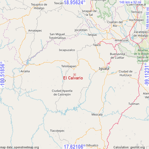
El Calvario GPS coordinates[2]
18° 17' 23.784" North, 99° 48' 55.548" West
| Map corner | latitude | longitude |
|---|---|---|
| Upper-left | 18.95624°, | -100.51856° |
| Center: | 18.28994°, | -99.81543° |
| Lower-right: | 17.62106°, | -99.11231° |
| Map W x H: | 148.5×148.5 km | = 92.3×92.3mi |
| max Lat: | 32.7° ⇑75% North |
| El Calvario: | 18.28994° |
| min Lat: | ⇓25% South 14.53588° |
| min Long | El Calvario | max Long |
| -117.105° | -99.81543° | -86.73105° |
| W 38.4%⇐ | ⇒61.6% E |
Elevation
Elevation of El Calvario is 1716 m = 5630 ft, and this is 462.3 m = 1517 ft above average elevation for this country.
| Max E: |
3497 m = 11473 ft | 40.6% |
| El Calvario | 1716 m 5630 ft | |
| Avg. | 1253.7 m = 4113 ft | |
Min E: |
-1 m = -3 ft | 59.4% |
See also: Mexico elevation on elevation.city.
Geographical zone
El Calvario is located in North Torrid zone (between Equator and Tropic of Cancer). Distance of this Northern Tropic circle is 572.3 km =355.6 mi to North.| Distance of | km | miles | from El Calvario |
|---|---|---|---|
| North Pole | 7973.4 | 4954.4 | to North |
| Arctic Circle | 5367.5 | 3335.2 | to North |
| Tropic Cancer | 572.3 | 355.6 | to North |
| Equator | 2033.7 | 1263.7 | to South |


Nearby cities:
15 places around El Calvario: (largest is in red/bold)
• Acatempan
7.8 km =4.8 mi,  293°
293°
• Apetlanca
9.6 km =6 mi,  162°
162°
• Chilacachapa
5.9 km =3.7 mi,  107°
107°
• Coatepec Costales
11.3 km =7 mi,  61°
61°
• Colonia el Pedregal
7.9 km =4.9 mi,  326°
326°
• Cuaxilotla
13.7 km =8.5 mi,  196°
196°
• El Capire
13.6 km =8.5 mi, 291°
• Los Sauces
3.3 km =2.1 mi,  218°
218°
• San Martín Pachivia (Pachivia)
13.5 km =8.4 mi,  12°
12°
• Tehuixtla
12.8 km =8 mi,  283°
283°
• Teloloapan
10.4 km =6.5 mi, 325°
• Tianquizolco
9.8 km =6.1 mi,  139°
139°
• Tlacaquipa
9.2 km =5.7 mi, 220°
• Tlacuitlapa
12.2 km =7.6 mi,  69°
69°
• Tonalapa del Río
14.3 km =8.9 mi, 66°
Sources, notices
• [Note1] Compared only with cities in Mexico existing in our database
• [Src1] Map data: © OpenStreetMap contributors (CC-BY-SA)
• [Src2] Other city data from geonames.org with taken over terms of usage.
• [Src3] Geographical zone / Annual Mean Temperature by Robert A. Rohde @ Wikipedia
