Chilacachapa geodata
Chilacachapa (Guerrero) is a populated place; located in Mexico in America/Mexico_City (GMT-6) time zone. With population of 1,982 people, there are 4396 cities with bigger population in this country. Compared to other cities in Mexico, 75.2% of cities are located further ↑North; 61% of cities are located further →East and 57.1% of cities have lower elevation than Chilacachapa. Note1


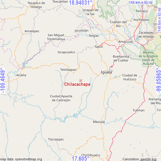
Chilacachapa GPS coordinates[2]
18° 16' 26.184" North, 99° 45' 42.372" West
| Map corner | latitude | longitude |
|---|---|---|
| Upper-left | 18.94031°, | -100.4649° |
| Center: | 18.27394°, | -99.76177° |
| Lower-right: | 17.605°, | -99.05865° |
| Map W x H: | 148.5×148.5 km | = 92.3×92.3mi |
| max Lat: | 32.7° ⇑75.2% North |
| Chilacachapa: | 18.27394° |
| min Lat: | ⇓24.8% South 14.53588° |
| min Long | Chilacachapa | max Long |
| -117.105° | -99.76177° | -86.73105° |
| W 39%⇐ | ⇒61% E |
Elevation
Elevation of Chilacachapa is 1663 m = 5456 ft, and this is 409.3 m = 1343 ft above average elevation for this country.
| Max E: |
3497 m = 11473 ft | 42.9% |
| Chilacachapa | 1663 m 5456 ft | |
| Avg. | 1253.7 m = 4113 ft | |
Min E: |
-1 m = -3 ft | 57.1% |
See also: Mexico elevation on elevation.city.
Geographical zone
Chilacachapa is located in North Torrid zone (between Equator and Tropic of Cancer). Distance of this Northern Tropic circle is 574 km =356.7 mi to North.| Distance of | km | miles | from Chilacachapa |
|---|---|---|---|
| North Pole | 7975.2 | 4955.6 | to North |
| Arctic Circle | 5369.3 | 3336.3 | to North |
| Tropic Cancer | 574 | 356.7 | to North |
| Equator | 2031.9 | 1262.6 | to South |


Nearby cities:
15 places around Chilacachapa: (largest is in red/bold)
• Acatempan
13.7 km =8.5 mi,  290°
290°
• Apango
9.8 km =6.1 mi,  116°
116°
• Apetlanca
7.9 km =4.9 mi,  200°
200°
• Apipilulco
13.2 km =8.2 mi,  134°
134°
• Atlixtac
12.3 km =7.6 mi, 131°
• Coatepec Costales
8.4 km =5.2 mi,  30°
30°
• Cocula
11.1 km =6.9 mi,  109°
109°
• Colonia el Pedregal
13.1 km =8.1 mi,  310°
310°
• El Calvario
5.9 km =3.7 mi, 287°
• Los Sauces
7.8 km =4.8 mi,  263°
263°
• Tianquizolco
5.7 km =3.5 mi,  172°
172°
• Tlacaquipa
12.8 km =8 mi,  245°
245°
• Tlacuitlapa
8.4 km =5.2 mi,  43°
43°
• Tlanipatlán
12.8 km =8 mi, 173°
• Tonalapa del Río
10.6 km =6.6 mi, 44°
Sources, notices
• [Note1] Compared only with cities in Mexico existing in our database
• [Src1] Map data: © OpenStreetMap contributors (CC-BY-SA)
• [Src2] Other city data from geonames.org with taken over terms of usage.
• [Src3] Geographical zone / Annual Mean Temperature by Robert A. Rohde @ Wikipedia
