San Miguel Reyes geodata
San Miguel Reyes (Oaxaca) is a populated place; located in Mexico in America/Mexico_City (GMT-6) time zone. With population of 813 people, there are 10742 cities with bigger population in this country. Compared to other cities in Mexico, 90% of cities are located further ↑North; 65% of cities are located further ←West and 63.7% of cities have higher elevation than San Miguel Reyes. Note1


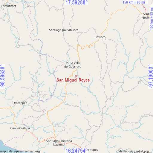
San Miguel Reyes GPS coordinates[2]
16° 55' 17.076" North, 97° 53' 35.34" West
| Map corner | latitude | longitude |
|---|---|---|
| Upper-left | 17.59288°, | -98.59628° |
| Center: | 16.92141°, | -97.89315° |
| Lower-right: | 16.24754°, | -97.19003° |
| Map W x H: | 149.6×149.6 km | = 93×93mi |
| max Lat: | 32.7° ⇑90% North |
| San Miguel Reyes: | 16.92141° |
| min Lat: | ⇓10% South 14.53588° |
| min Long | San Miguel Reye | max Long |
| -117.105° | -97.89315° | -86.73105° |
| W 65%⇐ | ⇒35% E |
Elevation
Elevation of San Miguel Reyes is 768 m = 2520 ft, and this is 485.7 m = 1594 ft below average elevation for this country.
| Max E: |
3497 m = 11473 ft | 63.7% |
| Avg. | 1253.7 m = 4113 ft | |
| San Miguel Reyes | 768 m = 2520 ft | |
Min E: |
-1 m = -3 ft | 36.3% |
See also: Mexico elevation on elevation.city.
Geographical zone
San Miguel Reyes is located in North Torrid zone (between Equator and Tropic of Cancer). Distance of this Northern Tropic circle is 724.4 km =450.1 mi to North.| Distance of | km | miles | from San Miguel Reyes |
|---|---|---|---|
| North Pole | 8125.6 | 5049 | to North |
| Arctic Circle | 5519.7 | 3429.8 | to North |
| Tropic Cancer | 724.4 | 450.1 | to North |
| Equator | 1881.5 | 1169.1 | to South |


Nearby cities:
15 places around San Miguel Reyes: (largest is in red/bold)
• Aquiles Serdán
13.1 km =8.1 mi,  229°
229°
• Concepción del Progreso
14.3 km =8.9 mi,  13°
13°
• Concepción las Mesas
8.5 km =5.3 mi,  237°
237°
• Constancia del Rosario
14 km =8.7 mi,  338°
338°
• El Rosario
11.2 km =7 mi, 234°
• Guadalupe Nuevo Centro
13.9 km =8.6 mi,  183°
183°
• La Zafra
7.1 km =4.4 mi,  4°
4°
• Malpica
10.2 km =6.3 mi,  350°
350°
• Miramar
13.4 km =8.3 mi,  48°
48°
• Putla Villa de Guerrero
12.3 km =7.6 mi, 342°
• San Juan Lagunas
9.4 km =5.8 mi,  334°
334°
• San Juan Teponaxtla
12.8 km =8 mi,  17°
17°
• San Pedro Siniyuvi
8.9 km =5.5 mi,  38°
38°
• San Sebastián Nopalera
12.5 km =7.8 mi,  78°
78°
• Zimatlán
6.8 km =4.2 mi,  73°
73°
Sources, notices
• [Note1] Compared only with cities in Mexico existing in our database
• [Src1] Map data: © OpenStreetMap contributors (CC-BY-SA)
• [Src2] Other city data from geonames.org with taken over terms of usage.
• [Src3] Geographical zone / Annual Mean Temperature by Robert A. Rohde @ Wikipedia
