Concepción las Mesas geodata
Concepción las Mesas (Oaxaca) is a populated place; located in Mexico in America/Mexico_City (GMT-6) time zone. With population of 543 people, there are 15651 cities with bigger population in this country. Compared to other cities in Mexico, 90.6% of cities are located further ↑North; 64.1% of cities are located further ←West and 67.7% of cities have higher elevation than Concepción las Mesas. Note1


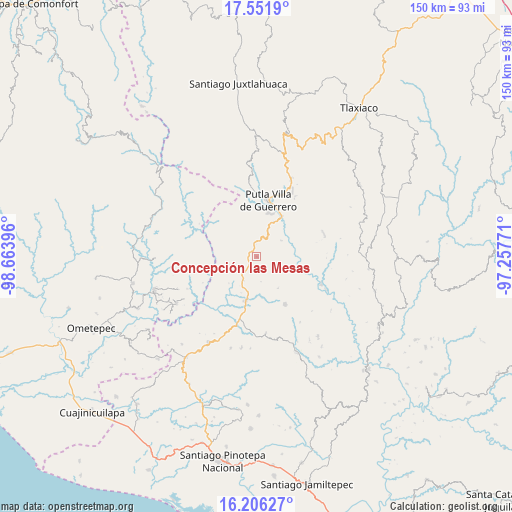
Concepción las Mesas GPS coordinates[2]
16° 52' 49.008" North, 97° 57' 38.988" West
| Map corner | latitude | longitude |
|---|---|---|
| Upper-left | 17.5519°, | -98.66396° |
| Center: | 16.88028°, | -97.96083° |
| Lower-right: | 16.20627°, | -97.25771° |
| Map W x H: | 149.6×149.6 km | = 93×93mi |
| max Lat: | 32.7° ⇑90.6% North |
| Concepción las Mesas: | 16.88028° |
| min Lat: | ⇓9.4% South 14.53588° |
| min Long | Concepción las | max Long |
| -117.105° | -97.96083° | -86.73105° |
| W 64.1%⇐ | ⇒35.9% E |
Elevation
Elevation of Concepción las Mesas is 542 m = 1778 ft, and this is 711.7 m = 2335 ft below average elevation for this country.
| Max E: |
3497 m = 11473 ft | 67.7% |
| Avg. | 1253.7 m = 4113 ft | |
| Concepción las Mesas | 542 m = 1778 ft | |
Min E: |
-1 m = -3 ft | 32.3% |
See also: Mexico elevation on elevation.city.
Geographical zone
Concepción las Mesas is located in North Torrid zone (between Equator and Tropic of Cancer). Distance of this Northern Tropic circle is 729 km =453 mi to North.| Distance of | km | miles | from Concepción las Mesas |
|---|---|---|---|
| North Pole | 8130.2 | 5051.9 | to North |
| Arctic Circle | 5524.3 | 3432.6 | to North |
| Tropic Cancer | 729 | 453 | to North |
| Equator | 1876.9 | 1166.3 | to South |


Nearby cities:
15 places around Concepción las Mesas: (largest is in red/bold)
• Aquiles Serdán
4.7 km =2.9 mi,  215°
215°
• El Rosario
2.7 km =1.7 mi, 223°
• El Tapanco
8.1 km =5 mi,  206°
206°
• Guadalupe Nuevo Centro
11.2 km =7 mi,  146°
146°
• La Zafra
14 km =8.7 mi,  33°
33°
• Malpica
15.6 km =9.7 mi,  20°
20°
• Putla Villa de Guerrero
16.6 km =10.3 mi,  11°
11°
• San José de las Flores
9.8 km =6.1 mi,  292°
292°
• San Juan Cabeza del Río
16.4 km =10.2 mi, 149°
• San Juan Lagunas
13.4 km =8.3 mi, 13°
• San Miguel Reyes
8.5 km =5.3 mi,  57°
57°
• San Vicente Piñas
15 km =9.3 mi,  225°
225°
• Santa Cruz Tutiahua
13.5 km =8.4 mi,  157°
157°
• Santa María Zacatepec
13.3 km =8.3 mi,  193°
193°
• Zimatlán
15.2 km =9.4 mi, 64°
Sources, notices
• [Note1] Compared only with cities in Mexico existing in our database
• [Src1] Map data: © OpenStreetMap contributors (CC-BY-SA)
• [Src2] Other city data from geonames.org with taken over terms of usage.
• [Src3] Geographical zone / Annual Mean Temperature by Robert A. Rohde @ Wikipedia
