Huehuetla geodata
Huehuetla (Hidalgo) is a seat of a second-order administrative division; located in Mexico in America/Mexico_City (GMT-6) time zone. With population of 2,821 people, there are 3144 cities with bigger population in this country. Compared to other cities in Mexico, 66.9% of cities are located further ↓South; 62.7% of cities are located further ←West and 69.8% of cities have higher elevation than Huehuetla. Note1


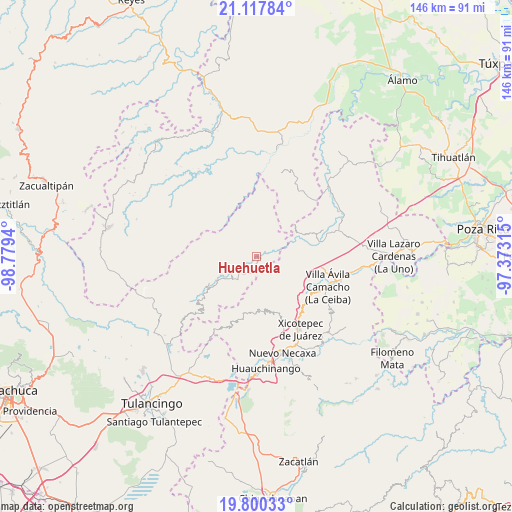
Huehuetla GPS coordinates[2]
20° 27' 37.8" North, 98° 4' 34.572" West
| Map corner | latitude | longitude |
|---|---|---|
| Upper-left | 21.11784°, | -98.7794° |
| Center: | 20.4605°, | -98.07627° |
| Lower-right: | 19.80033°, | -97.37315° |
| Map W x H: | 146.5×146.5 km | = 91×91mi |
| max Lat: | 32.7° ⇑33.1% North |
| Huehuetla: | 20.4605° |
| min Lat: | ⇓66.9% South 14.53588° |
| min Long | Huehuetla | max Long |
| -117.105° | -98.07627° | -86.73105° |
| W 62.7%⇐ | ⇒37.3% E |
Elevation
Elevation of Huehuetla is 426 m = 1398 ft, and this is 827.7 m = 2716 ft below average elevation for this country.
| Max E: |
3497 m = 11473 ft | 69.8% |
| Avg. | 1253.7 m = 4113 ft | |
| Huehuetla | 426 m = 1398 ft | |
Min E: |
-1 m = -3 ft | 30.2% |
See also: Mexico elevation on elevation.city.
Geographical zone
Huehuetla is located in North Torrid zone (between Equator and Tropic of Cancer). Distance of this Northern Tropic circle is 330.9 km =205.6 mi to North.| Distance of | km | miles | from Huehuetla |
|---|---|---|---|
| North Pole | 7732.1 | 4804.5 | to North |
| Arctic Circle | 5126.2 | 3185.3 | to North |
| Tropic Cancer | 330.9 | 205.6 | to North |
| Equator | 2275 | 1413.6 | to South |


Nearby cities:
15 places around Huehuetla: (largest is in red/bold)
• Acalmán
4.7 km =2.9 mi,  157°
157°
• Acuautla
5.5 km =3.4 mi,  53°
53°
• Barrio Aztlán
1.1 km =0.7 mi,  300°
300°
• Cuaxtla
9.7 km =6 mi,  177°
177°
• El Ocotal
7.2 km =4.5 mi,  194°
194°
• El Rincón
7.8 km =4.8 mi,  110°
110°
• San Ambrosio
9.5 km =5.9 mi,  37°
37°
• San Andrés
5.1 km =3.2 mi,  336°
336°
• San Antonio el Grande
4.3 km =2.7 mi,  95°
95°
• San Clemente
9.6 km =6 mi,  229°
229°
• San Esteban
9.5 km =5.9 mi,  10°
10°
• San Gregorio
7.4 km =4.6 mi,  55°
55°
• Santa Inés
1.6 km =1 mi,  250°
250°
• Santa Úrsula
5.4 km =3.4 mi,  213°
213°
• Tlaxco
6.4 km =4 mi,  130°
130°
Sources, notices
• [Note1] Compared only with cities in Mexico existing in our database
• [Src1] Map data: © OpenStreetMap contributors (CC-BY-SA)
• [Src2] Other city data from geonames.org with taken over terms of usage.
• [Src3] Geographical zone / Annual Mean Temperature by Robert A. Rohde @ Wikipedia
