San Felipe Otlaltepec geodata
San Felipe Otlaltepec (Puebla) is a populated place; located in Mexico in America/Mexico_City (GMT-6) time zone. With population of 1,899 people, there are 4580 cities with bigger population in this country. Compared to other cities in Mexico, 73.8% of cities are located further ↑North; 64.7% of cities are located further ←West and 66.2% of cities have lower elevation than San Felipe Otlaltepec. Note1


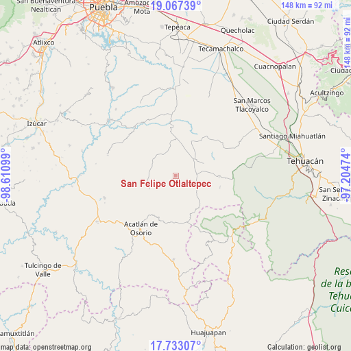
San Felipe Otlaltepec GPS coordinates[2]
18° 24' 5.472" North, 97° 54' 28.296" West
| Map corner | latitude | longitude |
|---|---|---|
| Upper-left | 19.06739°, | -98.61099° |
| Center: | 18.40152°, | -97.90786° |
| Lower-right: | 17.73307°, | -97.20474° |
| Map W x H: | 148.4×148.4 km | = 92.2×92.2mi |
| max Lat: | 32.7° ⇑73.8% North |
| San Felipe Otlaltepec: | 18.40152° |
| min Lat: | ⇓26.2% South 14.53588° |
| min Long | San Felipe Otla | max Long |
| -117.105° | -97.90786° | -86.73105° |
| W 64.7%⇐ | ⇒35.3% E |
Elevation
Elevation of San Felipe Otlaltepec is 1855 m = 6086 ft, and this is 601.3 m = 1973 ft above average elevation for this country.
| Max E: |
3497 m = 11473 ft | 33.8% |
| San Felipe Otlaltepec | 1855 m 6086 ft | |
| Avg. | 1253.7 m = 4113 ft | |
Min E: |
-1 m = -3 ft | 66.2% |
See also: Mexico elevation on elevation.city.
Geographical zone
San Felipe Otlaltepec is located in North Torrid zone (between Equator and Tropic of Cancer). Distance of this Northern Tropic circle is 559.9 km =347.9 mi to North.| Distance of | km | miles | from San Felipe Otlaltepec |
|---|---|---|---|
| North Pole | 7961 | 4946.7 | to North |
| Arctic Circle | 5355.1 | 3327.5 | to North |
| Tropic Cancer | 559.9 | 347.9 | to North |
| Equator | 2046.1 | 1271.4 | to South |


Nearby cities:
15 places around San Felipe Otlaltepec: (largest is in red/bold)
• Agua Santa Ana
13.7 km =8.5 mi,  338°
338°
• Ahuatempan
11.7 km =7.3 mi,  276°
276°
• Almolonga
10.2 km =6.3 mi,  324°
324°
• Chapultepec (Santo Domingo)
12.9 km =8 mi, 317°
• Guadalupe Victoria
16.4 km =10.2 mi,  23°
23°
• Huajoyuca
12.7 km =7.9 mi,  345°
345°
• Huejonapan
7.7 km =4.8 mi, 349°
• La Concepción
13.4 km =8.3 mi,  262°
262°
• Mariscala
13 km =8.1 mi,  355°
355°
• Moralillo
16.7 km =10.4 mi, 346°
• San Juan Ixcaquixtla
10.4 km =6.5 mi,  50°
50°
• San Juan Nepomuceno
11.8 km =7.3 mi,  265°
265°
• San Mateo Zoyamazalco
11.6 km =7.2 mi,  79°
79°
• San Vicente Coyotepec
8.3 km =5.2 mi,  87°
87°
• Tula
15.2 km =9.4 mi, 359°
Sources, notices
• [Note1] Compared only with cities in Mexico existing in our database
• [Src1] Map data: © OpenStreetMap contributors (CC-BY-SA)
• [Src2] Other city data from geonames.org with taken over terms of usage.
• [Src3] Geographical zone / Annual Mean Temperature by Robert A. Rohde @ Wikipedia
