Tenepanigia (Santa Elena) geodata
Tenepanigia (Santa Elena) (Puebla) is a populated place; located in Mexico in America/Mexico_City (GMT-6) time zone. With population of 885 people, there are 9853 cities with bigger population in this country. Compared to other cities in Mexico, 56.3% of cities are located further ↓South; 66.5% of cities are located further ←West and 56.5% of cities have higher elevation than Tenepanigia (Santa Elena). Note1
Current local time in Tenepanigia (Santa Elena):
07:08 AM, WednesdayDifference from your time zone: hours


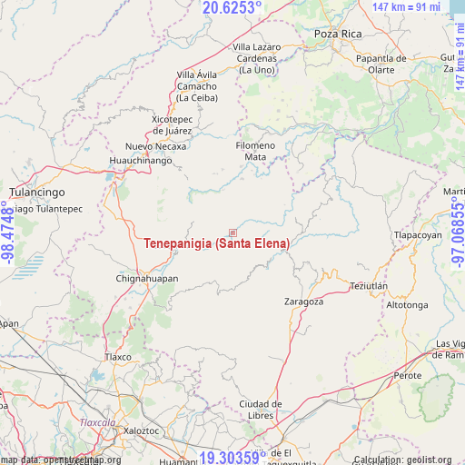
Tenepanigia (Santa Elena) GPS coordinates[2]
19° 57' 56.988" North, 97° 46' 18.012" West
| Map corner | latitude | longitude |
|---|---|---|
| Upper-left | 20.6253°, | -98.4748° |
| Center: | 19.96583°, | -97.77167° |
| Lower-right: | 19.30359°, | -97.06855° |
| Map W x H: | 147×147 km | = 91.3×91.3mi |
| max Lat: | 32.7° ⇑43.7% North |
| Tenepanigia (Santa Elena): | 19.96583° |
| min Lat: | ⇓56.3% South 14.53588° |
| min Long | Tenepanigia (Sa | max Long |
| -117.105° | -97.77167° | -86.73105° |
| W 66.5%⇐ | ⇒33.5% E |
Elevation
Elevation of Tenepanigia (Santa Elena) is 1140 m = 3740 ft, and this is 113.7 m = 373 ft below average elevation for this country.
| Max E: |
3497 m = 11473 ft | 56.5% |
| Avg. | 1253.7 m = 4113 ft | |
| Tenepanigia (Santa Elena) | 1140 m = 3740 ft | |
Min E: |
-1 m = -3 ft | 43.5% |
See also: Mexico elevation on elevation.city.
Geographical zone
Tenepanigia (Santa Elena) is located in North Torrid zone (between Equator and Tropic of Cancer). Distance of this Northern Tropic circle is 385.9 km =239.8 mi to North.| Distance of | km | miles | from Tenepanigia (Santa Elena) |
|---|---|---|---|
| North Pole | 7787.1 | 4838.7 | to North |
| Arctic Circle | 5181.2 | 3219.4 | to North |
| Tropic Cancer | 385.9 | 239.8 | to North |
| Equator | 2220 | 1379.4 | to South |


Nearby cities:
15 places around Tenepanigia (Santa Elena): (largest is in red/bold)
• Ahuatlán
6.7 km =4.2 mi,  216°
216°
• Cerro Verde (Ejecatepeco)
5.1 km =3.2 mi,  207°
207°
• Chicometepec (San Simón)
5.9 km =3.7 mi,  266°
266°
• Cuautempan
6.3 km =3.9 mi,  202°
202°
• San Antonio Taltzintán
7.6 km =4.7 mi,  146°
146°
• Tapayula
6.5 km =4 mi,  26°
26°
• Tepango
4.9 km =3 mi,  327°
327°
• Tepetzintla
7.3 km =4.5 mi, 271°
• Tlamanca de Hernández
4.6 km =2.9 mi,  256°
256°
• Tlapacholoya
3.2 km =2 mi, 213°
• Tonalixco
7.3 km =4.5 mi,  283°
283°
• Totomoxtla
5.3 km =3.3 mi,  229°
229°
• Vista Hermosa
6.3 km =3.9 mi,  190°
190°
• Zapotitlán
7.3 km =4.5 mi,  56°
56°
• Zongozotla
4.9 km =3 mi,  72°
72°
Sources, notices
• [Note1] Compared only with cities in Mexico existing in our database
• [Src1] Map data: © OpenStreetMap contributors (CC-BY-SA)
• [Src2] Other city data from geonames.org with taken over terms of usage.
• [Src3] Geographical zone / Annual Mean Temperature by Robert A. Rohde @ Wikipedia
