San Cristóbal geodata
San Cristóbal (Oaxaca) is a populated place; located in Mexico in America/Mexico_City (GMT-6) time zone. With population of 658 people, there are 13187 cities with bigger population in this country. Compared to other cities in Mexico, 94.5% of cities are located further ↑North; 65.2% of cities are located further ←West and 72.6% of cities have higher elevation than San Cristóbal. Note1


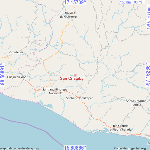
San Cristóbal GPS coordinates[2]
16° 29' 2.58" North, 97° 51' 56.808" West
| Map corner | latitude | longitude |
|---|---|---|
| Upper-left | 17.15709°, | -98.56891° |
| Center: | 16.48405°, | -97.86578° |
| Lower-right: | 15.80866°, | -97.16266° |
| Map W x H: | 149.9×149.9 km | = 93.1×93.1mi |
| max Lat: | 32.7° ⇑94.5% North |
| San Cristóbal: | 16.48405° |
| min Lat: | ⇓5.5% South 14.53588° |
| min Long | San Cristóbal | max Long |
| -117.105° | -97.86578° | -86.73105° |
| W 65.2%⇐ | ⇒34.8% E |
Elevation
Elevation of San Cristóbal is 305 m = 1001 ft, and this is 948.7 m = 3113 ft below average elevation for this country.
| Max E: |
3497 m = 11473 ft | 72.6% |
| Avg. | 1253.7 m = 4113 ft | |
| San Cristóbal | 305 m = 1001 ft | |
Min E: |
-1 m = -3 ft | 27.4% |
See also: Mexico elevation on elevation.city.
Geographical zone
San Cristóbal is located in North Torrid zone (between Equator and Tropic of Cancer). Distance of this Northern Tropic circle is 773.1 km =480.4 mi to North.| Distance of | km | miles | from San Cristóbal |
|---|---|---|---|
| North Pole | 8174.2 | 5079.2 | to North |
| Arctic Circle | 5568.3 | 3460 | to North |
| Tropic Cancer | 773.1 | 480.4 | to North |
| Equator | 1832.9 | 1138.9 | to South |


Nearby cities:
15 places around San Cristóbal: (largest is in red/bold)
• El Carasol
9.6 km =6 mi,  70°
70°
• El Frutillo
9.7 km =6 mi,  83°
83°
• La Muralla
2.8 km =1.7 mi, 70°
• Nuevo Progreso
5.1 km =3.2 mi,  324°
324°
• Pinotepa de Don Luis
13.4 km =8.3 mi,  241°
241°
• San Agustín Chayuco
11 km =6.8 mi,  145°
145°
• San Juan Colorado
9.8 km =6.1 mi,  254°
254°
• San Juan Yosocani
6.7 km =4.2 mi,  213°
213°
• San Lorenzo
10 km =6.2 mi,  185°
185°
• San Miguel Tetepelcingo
10.3 km =6.4 mi,  201°
201°
• San Pedro Atoyac
12.8 km =8 mi,  272°
272°
• Santa María Nutío
4.1 km =2.5 mi, 272°
• Santa María Yosocani
6.1 km =3.8 mi,  183°
183°
• Siniyuvi
6.6 km =4.1 mi,  262°
262°
• Villa Nueva
9.7 km =6 mi,  27°
27°
Sources, notices
• [Note1] Compared only with cities in Mexico existing in our database
• [Src1] Map data: © OpenStreetMap contributors (CC-BY-SA)
• [Src2] Other city data from geonames.org with taken over terms of usage.
• [Src3] Geographical zone / Annual Mean Temperature by Robert A. Rohde @ Wikipedia
