San Agustín Chayuco geodata
San Agustín Chayuco (Oaxaca) is a seat of a second-order administrative division; located in Mexico in America/Mexico_City (GMT-6) time zone. With population of 2,004 people, there are 4343 cities with bigger population in this country. Compared to other cities in Mexico, 95% of cities are located further ↑North; 66% of cities are located further ←West and 73.9% of cities have higher elevation than San Agustín Chayuco. Note1


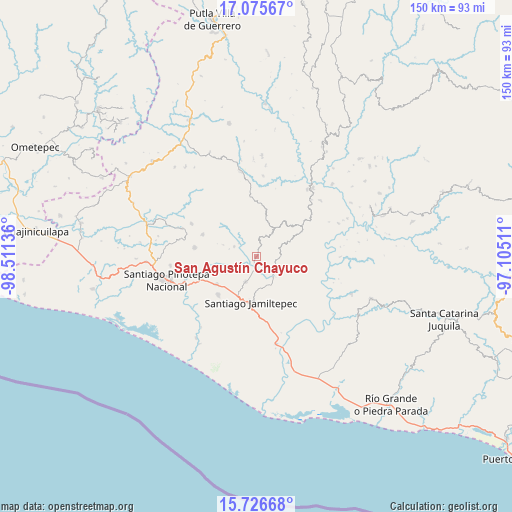
San Agustín Chayuco GPS coordinates[2]
16° 24' 8.424" North, 97° 48' 29.628" West
| Map corner | latitude | longitude |
|---|---|---|
| Upper-left | 17.07567°, | -98.51136° |
| Center: | 16.40234°, | -97.80823° |
| Lower-right: | 15.72668°, | -97.10511° |
| Map W x H: | 150×150 km | = 93.2×93.2mi |
| max Lat: | 32.7° ⇑95% North |
| San Agustín Chayuco: | 16.40234° |
| min Lat: | ⇓5% South 14.53588° |
| min Long | San Agustín Ch | max Long |
| -117.105° | -97.80823° | -86.73105° |
| W 66%⇐ | ⇒34% E |
Elevation
Elevation of San Agustín Chayuco is 259 m = 850 ft, and this is 994.7 m = 3263 ft below average elevation for this country.
| Max E: |
3497 m = 11473 ft | 73.9% |
| Avg. | 1253.7 m = 4113 ft | |
| San Agustín Chayuco | 259 m = 850 ft | |
Min E: |
-1 m = -3 ft | 26.1% |
See also: Mexico elevation on elevation.city.
Geographical zone
San Agustín Chayuco is located in North Torrid zone (between Equator and Tropic of Cancer). Distance of this Northern Tropic circle is 782.1 km =486 mi to North.| Distance of | km | miles | from San Agustín Chayuco |
|---|---|---|---|
| North Pole | 8183.3 | 5084.9 | to North |
| Arctic Circle | 5577.4 | 3465.6 | to North |
| Tropic Cancer | 782.1 | 486 | to North |
| Equator | 1823.8 | 1133.3 | to South |


Nearby cities:
15 places around San Agustín Chayuco: (largest is in red/bold)
• Cubitán de Dolores
10 km =6.2 mi,  241°
241°
• El Carasol
12.7 km =7.9 mi,  13°
13°
• El Frutillo
10.7 km =6.6 mi,  19°
19°
• Jamiltepec
13.4 km =8.3 mi,  187°
187°
• La Muralla
10.6 km =6.6 mi,  340°
340°
• San Cristóbal
11 km =6.8 mi,  325°
325°
• San José de las Flores
7 km =4.3 mi,  90°
90°
• San Juan Yosocani
10.5 km =6.5 mi,  289°
289°
• San Lorenzo
7.1 km =4.4 mi,  263°
263°
• San Miguel Tetepelcingo
9.9 km =6.2 mi,  267°
267°
• Santa Catarina Mechoacán
8 km =5 mi,  202°
202°
• Santa Elena Comaltepec
9.3 km =5.8 mi,  173°
173°
• Santa María Nutío
13.8 km =8.6 mi,  312°
312°
• Santa María Yosocani
7.2 km =4.5 mi,  295°
295°
• Santiago Tetepec
11 km =6.8 mi,  144°
144°
Sources, notices
• [Note1] Compared only with cities in Mexico existing in our database
• [Src1] Map data: © OpenStreetMap contributors (CC-BY-SA)
• [Src2] Other city data from geonames.org with taken over terms of usage.
• [Src3] Geographical zone / Annual Mean Temperature by Robert A. Rohde @ Wikipedia
