Espita geodata
Espita (Yucatán) is a seat of a second-order administrative division; located in Mexico in America/Merida (GMT-6) time zone. With population of 11,551 people, there are 831 cities with bigger population in this country. Compared to other cities in Mexico, 76.6% of cities are located further ↓South; 99.4% of cities are located further ←West and 89.4% of cities have higher elevation than Espita. Note1


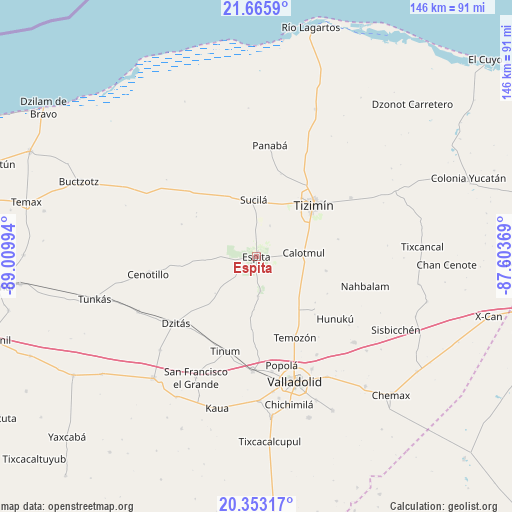
Espita GPS coordinates[2]
21° 0' 39.528" North, 88° 18' 24.516" West
| Map corner | latitude | longitude |
|---|---|---|
| Upper-left | 21.6659°, | -89.00994° |
| Center: | 21.01098°, | -88.30681° |
| Lower-right: | 20.35317°, | -87.60369° |
| Map W x H: | 146×146 km | = 90.7×90.7mi |
| max Lat: | 32.7° ⇑23.4% North |
| Espita: | 21.01098° |
| min Lat: | ⇓76.6% South 14.53588° |
| min Long | Espita | max Long |
| -117.105° | -88.30681° | -86.73105° |
| W 99.4%⇐ | ⇒0.59999999999999% E |
Elevation
Elevation of Espita is 26 m = 85 ft, and this is 1227.7 m = 4028 ft below average elevation for this country.
| Max E: |
3497 m = 11473 ft | 89.4% |
| Avg. | 1253.7 m = 4113 ft | |
| Espita | 26 m = 85 ft | |
Min E: |
-1 m = -3 ft | 10.6% |
See also: Mexico elevation on elevation.city.
Geographical zone
Espita is located in North Torrid zone (between Equator and Tropic of Cancer). Distance of this Northern Tropic circle is 269.7 km =167.6 mi to North.| Distance of | km | miles | from Espita |
|---|---|---|---|
| North Pole | 7670.9 | 4766.5 | to North |
| Arctic Circle | 5065 | 3147.2 | to North |
| Tropic Cancer | 269.7 | 167.6 | to North |
| Equator | 2336.2 | 1451.6 | to South |


Nearby cities:
15 places around Espita: (largest is in red/bold)
• Calotmul
13.5 km =8.4 mi,  85°
85°
• Cenotillo
31.3 km =19.4 mi,  260°
260°
• Dzitás
29.8 km =18.5 mi,  230°
230°
• Holcá
9.8 km =6.1 mi,  23°
23°
• Hunuku
28.6 km =17.8 mi,  128°
128°
• Kunche
11.1 km =6.9 mi,  177°
177°
• Nacuche
9.7 km =6 mi,  173°
173°
• Panabá
31.9 km =19.8 mi,  6°
6°
• Pocoboch
20.3 km =12.6 mi,  101°
101°
• Popola
31.7 km =19.7 mi, 166°
• Sucilá
16.2 km =10.1 mi,  357°
357°
• Sucopó
31.7 km =19.7 mi,  58°
58°
• Temozon
25.5 km =15.8 mi,  154°
154°
• Tinum
28.4 km =17.6 mi,  198°
198°
• Tizimín
21.8 km =13.5 mi,  47°
47°
Sources, notices
• [Note1] Compared only with cities in Mexico existing in our database
• [Src1] Map data: © OpenStreetMap contributors (CC-BY-SA)
• [Src2] Other city data from geonames.org with taken over terms of usage.
• [Src3] Geographical zone / Annual Mean Temperature by Robert A. Rohde @ Wikipedia
