Holcá geodata
Holcá (Yucatán) is a populated place; located in Mexico in America/Merida (GMT-6) time zone. With population of 552 people, there are 15449 cities with bigger population in this country. Compared to other cities in Mexico, 77.7% of cities are located further ↓South; 99.5% of cities are located further ←West and 88.6% of cities have higher elevation than Holcá. Note1


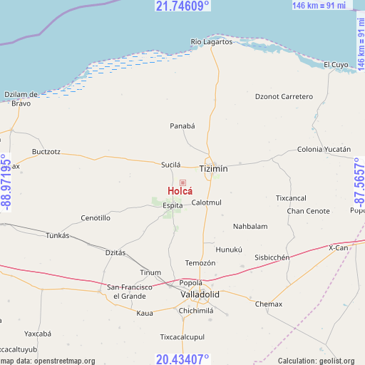
Holcá GPS coordinates[2]
21° 5' 29.508" North, 88° 16' 7.752" West
| Map corner | latitude | longitude |
|---|---|---|
| Upper-left | 21.74609°, | -88.97195° |
| Center: | 21.09153°, | -88.26882° |
| Lower-right: | 20.43407°, | -87.5657° |
| Map W x H: | 145.9×145.9 km | = 90.7×90.7mi |
| max Lat: | 32.7° ⇑22.3% North |
| Holcá: | 21.09153° |
| min Lat: | ⇓77.7% South 14.53588° |
| min Long | Holcá | max Long |
| -117.105° | -88.26882° | -86.73105° |
| W 99.5%⇐ | ⇒0.5% E |
Elevation
Elevation of Holcá is 28 m = 92 ft, and this is 1225.7 m = 4021 ft below average elevation for this country.
| Max E: |
3497 m = 11473 ft | 88.6% |
| Avg. | 1253.7 m = 4113 ft | |
| Holcá | 28 m = 92 ft | |
Min E: |
-1 m = -3 ft | 11.4% |
See also: Mexico elevation on elevation.city.
Geographical zone
Holcá is located in North Torrid zone (between Equator and Tropic of Cancer). Distance of this Northern Tropic circle is 260.8 km =162.1 mi to North.| Distance of | km | miles | from Holcá |
|---|---|---|---|
| North Pole | 7661.9 | 4760.9 | to North |
| Arctic Circle | 5056 | 3141.7 | to North |
| Tropic Cancer | 260.8 | 162.1 | to North |
| Equator | 2345.2 | 1457.2 | to South |


Nearby cities:
15 places around Holcá: (largest is in red/bold)
• Calotmul
12.4 km =7.7 mi,  129°
129°
• Cenotillo
37.5 km =23.3 mi,  248°
248°
• Dzalbay
36.3 km =22.6 mi,  141°
141°
• Espita
9.8 km =6.1 mi,  203°
203°
• Hunuku
32.5 km =20.2 mi,  145°
145°
• Kunche
20.4 km =12.7 mi,  189°
189°
• Loché
35.4 km =22 mi,  21°
21°
• Nacuche
18.8 km =11.7 mi, 188°
• Panabá
22.7 km =14.1 mi,  359°
359°
• Pocoboch
20.6 km =12.8 mi, 129°
• Sucilá
8.6 km =5.3 mi,  327°
327°
• Sucopó
24.2 km =15 mi,  71°
71°
• Temozon
32.7 km =20.3 mi,  167°
167°
• Tinum
38.2 km =23.7 mi, 199°
• Tizimín
13.5 km =8.4 mi, 65°
Sources, notices
• [Note1] Compared only with cities in Mexico existing in our database
• [Src1] Map data: © OpenStreetMap contributors (CC-BY-SA)
• [Src2] Other city data from geonames.org with taken over terms of usage.
• [Src3] Geographical zone / Annual Mean Temperature by Robert A. Rohde @ Wikipedia
