Panabá geodata
Panabá (Yucatán) is a seat of a second-order administrative division; located in Mexico in America/Merida (GMT-6) time zone. With population of 5,232 people, there are 1768 cities with bigger population in this country. Compared to other cities in Mexico, 80% of cities are located further ↓South; 99.5% of cities are located further ←West and 91.2% of cities have higher elevation than Panabá. Note1


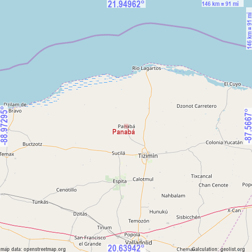
Panabá GPS coordinates[2]
21° 17' 45.528" North, 88° 16' 11.352" West
| Map corner | latitude | longitude |
|---|---|---|
| Upper-left | 21.94962°, | -88.97295° |
| Center: | 21.29598°, | -88.26982° |
| Lower-right: | 20.63942°, | -87.5667° |
| Map W x H: | 145.7×145.7 km | = 90.5×90.5mi |
| max Lat: | 32.7° ⇑20% North |
| Panabá: | 21.29598° |
| min Lat: | ⇓80% South 14.53588° |
| min Long | Panabá | max Long |
| -117.105° | -88.26982° | -86.73105° |
| W 99.5%⇐ | ⇒0.5% E |
Elevation
Elevation of Panabá is 21 m = 69 ft, and this is 1232.7 m = 4044 ft below average elevation for this country.
| Max E: |
3497 m = 11473 ft | 91.2% |
| Avg. | 1253.7 m = 4113 ft | |
| Panabá | 21 m = 69 ft | |
Min E: |
-1 m = -3 ft | 8.8% |
See also: Mexico elevation on elevation.city.
Geographical zone
Panabá is located in North Torrid zone (between Equator and Tropic of Cancer). Distance of this Northern Tropic circle is 238 km =147.9 mi to North.| Distance of | km | miles | from Panabá |
|---|---|---|---|
| North Pole | 7639.2 | 4746.8 | to North |
| Arctic Circle | 5033.3 | 3127.5 | to North |
| Tropic Cancer | 238 | 147.9 | to North |
| Equator | 2367.9 | 1471.3 | to South |


Nearby cities:
15 places around Panabá: (largest is in red/bold)
• Calotmul
32.1 km =19.9 mi,  162°
162°
• Cenotillo
50.5 km =31.4 mi,  223°
223°
• Dzonot Carretero
42.2 km =26.2 mi,  73°
73°
• Espita
31.9 km =19.8 mi,  186°
186°
• Holcá
22.7 km =14.1 mi,  179°
179°
• Kunche
42.9 km =26.7 mi, 184°
• Las Coloradas
45.1 km =28 mi,  39°
39°
• Loché
16.5 km =10.3 mi,  51°
51°
• Nacuche
41.4 km =25.7 mi, 183°
• Pocoboch
39.2 km =24.4 mi, 155°
• Río Lagartos
35.4 km =22 mi,  19°
19°
• San Felipe
30.3 km =18.8 mi,  7°
7°
• Sucilá
16.2 km =10.1 mi,  196°
196°
• Sucopó
27.5 km =17.1 mi,  122°
122°
• Tizimín
21 km =13 mi,  144°
144°
Sources, notices
• [Note1] Compared only with cities in Mexico existing in our database
• [Src1] Map data: © OpenStreetMap contributors (CC-BY-SA)
• [Src2] Other city data from geonames.org with taken over terms of usage.
• [Src3] Geographical zone / Annual Mean Temperature by Robert A. Rohde @ Wikipedia
