Sucilá geodata
Sucilá (Yucatán) is a seat of a second-order administrative division; located in Mexico in America/Merida (GMT-6) time zone. With population of 3,785 people, there are 2418 cities with bigger population in this country. Compared to other cities in Mexico, 78.7% of cities are located further ↓South; 99.4% of cities are located further ←West and 93% of cities have higher elevation than Sucilá. Note1


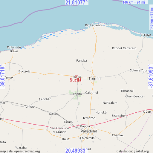
Sucilá GPS coordinates[2]
21° 9' 23.4" North, 88° 18' 50.58" West
| Map corner | latitude | longitude |
|---|---|---|
| Upper-left | 21.81077°, | -89.01718° |
| Center: | 21.1565°, | -88.31405° |
| Lower-right: | 20.49933°, | -87.61093° |
| Map W x H: | 145.8×145.8 km | = 90.6×90.6mi |
| max Lat: | 32.7° ⇑21.3% North |
| Sucilá: | 21.1565° |
| min Lat: | ⇓78.7% South 14.53588° |
| min Long | Sucilá | max Long |
| -117.105° | -88.31405° | -86.73105° |
| W 99.4%⇐ | ⇒0.59999999999999% E |
Elevation
Elevation of Sucilá is 17 m = 56 ft, and this is 1236.7 m = 4057 ft below average elevation for this country.
| Max E: |
3497 m = 11473 ft | 93% |
| Avg. | 1253.7 m = 4113 ft | |
| Sucilá | 17 m = 56 ft | |
Min E: |
-1 m = -3 ft | 7% |
See also: Mexico elevation on elevation.city.
Geographical zone
Sucilá is located in North Torrid zone (between Equator and Tropic of Cancer). Distance of this Northern Tropic circle is 253.5 km =157.5 mi to North.| Distance of | km | miles | from Sucilá |
|---|---|---|---|
| North Pole | 7654.7 | 4756.4 | to North |
| Arctic Circle | 5048.8 | 3137.2 | to North |
| Tropic Cancer | 253.5 | 157.5 | to North |
| Equator | 2352.4 | 1461.7 | to South |


Nearby cities:
15 places around Sucilá: (largest is in red/bold)
• Calotmul
20.7 km =12.9 mi,  136°
136°
• Cenotillo
36.8 km =22.9 mi,  234°
234°
• Dzitás
41.6 km =25.8 mi,  212°
212°
• Espita
16.2 km =10.1 mi,  177°
177°
• Holcá
8.6 km =5.3 mi,  147°
147°
• Hunuku
41.1 km =25.5 mi, 145°
• Kunche
27.3 km =17 mi, 177°
• Loché
31.1 km =19.3 mi,  34°
34°
• Nacuche
25.8 km =16 mi, 175°
• Panabá
16.2 km =10.1 mi,  16°
16°
• Pocoboch
28.9 km =18 mi,  134°
134°
• Sucopó
27.7 km =17.2 mi,  88°
88°
• Temozon
40.9 km =25.4 mi,  163°
163°
• Tinum
44 km =27.3 mi,  190°
190°
• Tizimín
17 km =10.6 mi,  95°
95°
Sources, notices
• [Note1] Compared only with cities in Mexico existing in our database
• [Src1] Map data: © OpenStreetMap contributors (CC-BY-SA)
• [Src2] Other city data from geonames.org with taken over terms of usage.
• [Src3] Geographical zone / Annual Mean Temperature by Robert A. Rohde @ Wikipedia
