Calotmul geodata
Calotmul (Yucatán) is a seat of a second-order administrative division; located in Mexico in America/Merida (GMT-6) time zone. With population of 2,764 people, there are 3203 cities with bigger population in this country. Compared to other cities in Mexico, 76.8% of cities are located further ↓South; 99.6% of cities are located further ←West and 89.7% of cities have higher elevation than Calotmul. Note1


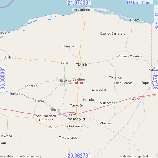
Calotmul GPS coordinates[2]
21° 1' 13.8" North, 88° 10' 38.028" West
| Map corner | latitude | longitude |
|---|---|---|
| Upper-left | 21.67538°, | -88.88036° |
| Center: | 21.0205°, | -88.17723° |
| Lower-right: | 20.36273°, | -87.47411° |
| Map W x H: | 146×146 km | = 90.7×90.7mi |
| max Lat: | 32.7° ⇑23.2% North |
| Calotmul: | 21.0205° |
| min Lat: | ⇓76.8% South 14.53588° |
| min Long | Calotmul | max Long |
| -117.105° | -88.17723° | -86.73105° |
| W 99.6%⇐ | ⇒0.40000000000001% E |
Elevation
Elevation of Calotmul is 25 m = 82 ft, and this is 1228.7 m = 4031 ft below average elevation for this country.
| Max E: |
3497 m = 11473 ft | 89.7% |
| Avg. | 1253.7 m = 4113 ft | |
| Calotmul | 25 m = 82 ft | |
Min E: |
-1 m = -3 ft | 10.3% |
See also: Mexico elevation on elevation.city.
Geographical zone
Calotmul is located in North Torrid zone (between Equator and Tropic of Cancer). Distance of this Northern Tropic circle is 268.7 km =167 mi to North.| Distance of | km | miles | from Calotmul |
|---|---|---|---|
| North Pole | 7669.8 | 4765.8 | to North |
| Arctic Circle | 5063.9 | 3146.6 | to North |
| Tropic Cancer | 268.7 | 167 | to North |
| Equator | 2337.3 | 1452.3 | to South |


Nearby cities:
15 places around Calotmul: (largest is in red/bold)
• Dzalbay
24.4 km =15.2 mi,  147°
147°
• Espita
13.5 km =8.4 mi,  265°
265°
• Holcá
12.4 km =7.7 mi,  309°
309°
• Hunuku
20.8 km =12.9 mi, 154°
• Kunche
17.8 km =11.1 mi,  226°
226°
• Nacuche
16.3 km =10.1 mi, 229°
• Panabá
32.1 km =19.9 mi,  342°
342°
• Pocoboch
8.2 km =5.1 mi,  128°
128°
• Popola
32.5 km =20.2 mi,  191°
191°
• Sucilá
20.7 km =12.9 mi,  316°
316°
• Sucopó
20.7 km =12.9 mi,  40°
40°
• Tahmuy
29.2 km =18.1 mi,  172°
172°
• Temozon
24.2 km =15 mi, 185°
• Tizimín
13.9 km =8.6 mi,  11°
11°
• Yalkoba
29.3 km =18.2 mi, 150°
Sources, notices
• [Note1] Compared only with cities in Mexico existing in our database
• [Src1] Map data: © OpenStreetMap contributors (CC-BY-SA)
• [Src2] Other city data from geonames.org with taken over terms of usage.
• [Src3] Geographical zone / Annual Mean Temperature by Robert A. Rohde @ Wikipedia
