Cuaxicala geodata
Cuaxicala (Puebla) is a populated place; located in Mexico in America/Mexico_City (GMT-6) time zone. With population of 774 people, there are 11290 cities with bigger population in this country. Compared to other cities in Mexico, 62.2% of cities are located further ↓South; 63.3% of cities are located further ←West and 50.9% of cities have lower elevation than Cuaxicala. Note1


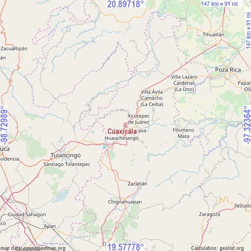
Cuaxicala GPS coordinates[2]
20° 14' 19.968" North, 98° 1' 36.336" West
| Map corner | latitude | longitude |
|---|---|---|
| Upper-left | 20.89718°, | -98.72989° |
| Center: | 20.23888°, | -98.02676° |
| Lower-right: | 19.57778°, | -97.32364° |
| Map W x H: | 146.7×146.7 km | = 91.2×91.2mi |
| max Lat: | 32.7° ⇑37.8% North |
| Cuaxicala: | 20.23888° |
| min Lat: | ⇓62.2% South 14.53588° |
| min Long | Cuaxicala | max Long |
| -117.105° | -98.02676° | -86.73105° |
| W 63.3%⇐ | ⇒36.7% E |
Elevation
Elevation of Cuaxicala is 1479 m = 4852 ft, and this is 225.3 m = 739 ft above average elevation for this country.
| Max E: |
3497 m = 11473 ft | 49.1% |
| Cuaxicala | 1479 m 4852 ft | |
| Avg. | 1253.7 m = 4113 ft | |
Min E: |
-1 m = -3 ft | 50.9% |
See also: Mexico elevation on elevation.city.
Geographical zone
Cuaxicala is located in North Torrid zone (between Equator and Tropic of Cancer). Distance of this Northern Tropic circle is 355.6 km =221 mi to North.| Distance of | km | miles | from Cuaxicala |
|---|---|---|---|
| North Pole | 7756.7 | 4819.8 | to North |
| Arctic Circle | 5150.8 | 3200.6 | to North |
| Tropic Cancer | 355.6 | 221 | to North |
| Equator | 2250.4 | 1398.3 | to South |


Nearby cities:
15 places around Cuaxicala: (largest is in red/bold)
• Copila
7 km =4.3 mi,  302°
302°
• Cuautlita
4.7 km =2.9 mi,  173°
173°
• Duraznotla
5.8 km =3.6 mi,  63°
63°
• Huilacapixtla
6.5 km =4 mi,  242°
242°
• Las Colonias de Hidalgo
7.1 km =4.4 mi,  132°
132°
• Necaxa
3.3 km =2.1 mi,  151°
151°
• Necaxaltépetl
3.2 km =2 mi,  97°
97°
• Nuevo Necaxa
3.8 km =2.4 mi, 146°
• Ozomatlán
4.7 km =2.9 mi,  346°
346°
• Patoltecoya
3.5 km =2.2 mi,  187°
187°
• San Isidro
6.9 km =4.3 mi,  79°
79°
• Tenango de las Flores
5.5 km =3.4 mi, 132°
• Tepetzintla de Galeana
4.6 km =2.9 mi,  4°
4°
• Tierra Negra
7.3 km =4.5 mi,  86°
86°
• Tzahuinco
5.1 km =3.2 mi,  143°
143°
Sources, notices
• [Note1] Compared only with cities in Mexico existing in our database
• [Src1] Map data: © OpenStreetMap contributors (CC-BY-SA)
• [Src2] Other city data from geonames.org with taken over terms of usage.
• [Src3] Geographical zone / Annual Mean Temperature by Robert A. Rohde @ Wikipedia
