Xochipala geodata
Xochipala (Guerrero) is a populated place; located in Mexico in America/Mexico_City (GMT-6) time zone. With population of 3,620 people, there are 2533 cities with bigger population in this country. Compared to other cities in Mexico, 80.4% of cities are located further ↑North; 59.2% of cities are located further →East and 58.7% of cities have higher elevation than Xochipala. Note1


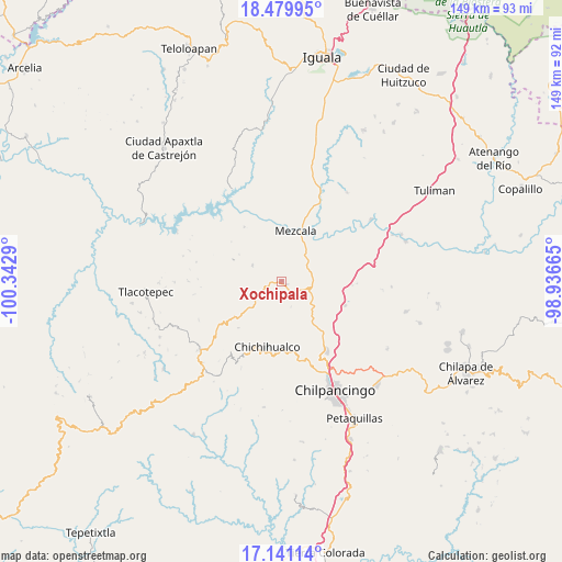
Xochipala GPS coordinates[2]
17° 48' 42.48" North, 99° 38' 23.172" West
| Map corner | latitude | longitude |
|---|---|---|
| Upper-left | 18.47995°, | -100.3429° |
| Center: | 17.8118°, | -99.63977° |
| Lower-right: | 17.14114°, | -98.93665° |
| Map W x H: | 148.9×148.9 km | = 92.5×92.5mi |
| max Lat: | 32.7° ⇑80.4% North |
| Xochipala: | 17.8118° |
| min Lat: | ⇓19.6% South 14.53588° |
| min Long | Xochipala | max Long |
| -117.105° | -99.63977° | -86.73105° |
| W 40.8%⇐ | ⇒59.2% E |
Elevation
Elevation of Xochipala is 1070 m = 3510 ft, and this is 183.7 m = 603 ft below average elevation for this country.
| Max E: |
3497 m = 11473 ft | 58.7% |
| Avg. | 1253.7 m = 4113 ft | |
| Xochipala | 1070 m = 3510 ft | |
Min E: |
-1 m = -3 ft | 41.3% |
See also: Mexico elevation on elevation.city.
Geographical zone
Xochipala is located in North Torrid zone (between Equator and Tropic of Cancer). Distance of this Northern Tropic circle is 625.4 km =388.6 mi to North.| Distance of | km | miles | from Xochipala |
|---|---|---|---|
| North Pole | 8026.6 | 4987.5 | to North |
| Arctic Circle | 5420.7 | 3368.3 | to North |
| Tropic Cancer | 625.4 | 388.6 | to North |
| Equator | 1980.5 | 1230.6 | to South |


Nearby cities:
15 places around Xochipala: (largest is in red/bold)
• Ameyaltepec
22.1 km =13.7 mi,  39°
39°
• Atlixtac
18.6 km =11.6 mi,  177°
177°
• Atzcala
18.6 km =11.6 mi,  352°
352°
• Axaxacualco
18.9 km =11.7 mi,  92°
92°
• Carrizalillo
8.8 km =5.5 mi,  299°
299°
• Chichihualco
17.4 km =10.8 mi,  192°
192°
• El Naranjo
16.5 km =10.3 mi,  222°
222°
• El Palmar
18.4 km =11.4 mi,  167°
167°
• Huitziltepec
18 km =11.2 mi,  110°
110°
• Mezcala
14 km =8.7 mi,  16°
16°
• San Juan Tetelcingo
17.8 km =11.1 mi,  46°
46°
• San Marcos Oacatzingo
21.6 km =13.4 mi, 50°
• Tlamamacan
17.2 km =10.7 mi, 44°
• Tlanipatla
19.9 km =12.4 mi, 91°
• Zumpango del Río
21.2 km =13.2 mi,  145°
145°
Sources, notices
• [Note1] Compared only with cities in Mexico existing in our database
• [Src1] Map data: © OpenStreetMap contributors (CC-BY-SA)
• [Src2] Other city data from geonames.org with taken over terms of usage.
• [Src3] Geographical zone / Annual Mean Temperature by Robert A. Rohde @ Wikipedia
