Jocutla geodata
Jocutla (Guerrero) is a populated place; located in Mexico in America/Mexico_City (GMT-6) time zone. With population of 809 people, there are 10801 cities with bigger population in this country. Compared to other cities in Mexico, 84.8% of cities are located further ↑North; 51.6% of cities are located further →East and 67.4% of cities have higher elevation than Jocutla. Note1


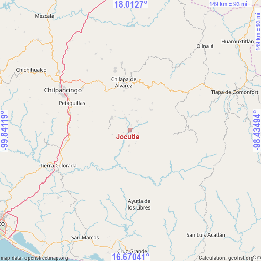
Jocutla GPS coordinates[2]
17° 20' 34.008" North, 99° 8' 17.016" West
| Map corner | latitude | longitude |
|---|---|---|
| Upper-left | 18.0127°, | -99.84119° |
| Center: | 17.34278°, | -99.13806° |
| Lower-right: | 16.67041°, | -98.43494° |
| Map W x H: | 149.2×149.3 km | = 92.7×92.8mi |
| max Lat: | 32.7° ⇑84.8% North |
| Jocutla: | 17.34278° |
| min Lat: | ⇓15.2% South 14.53588° |
| min Long | Jocutla | max Long |
| -117.105° | -99.13806° | -86.73105° |
| W 48.4%⇐ | ⇒51.6% E |
Elevation
Elevation of Jocutla is 563 m = 1847 ft, and this is 690.7 m = 2266 ft below average elevation for this country.
| Max E: |
3497 m = 11473 ft | 67.4% |
| Avg. | 1253.7 m = 4113 ft | |
| Jocutla | 563 m = 1847 ft | |
Min E: |
-1 m = -3 ft | 32.6% |
See also: Mexico elevation on elevation.city.
Geographical zone
Jocutla is located in North Torrid zone (between Equator and Tropic of Cancer). Distance of this Northern Tropic circle is 677.6 km =421 mi to North.| Distance of | km | miles | from Jocutla |
|---|---|---|---|
| North Pole | 8078.7 | 5019.9 | to North |
| Arctic Circle | 5472.8 | 3400.6 | to North |
| Tropic Cancer | 677.6 | 421 | to North |
| Equator | 1928.3 | 1198.2 | to South |


Nearby cities:
15 places around Jocutla: (largest is in red/bold)
• Colotlipa
8.3 km =5.2 mi,  338°
338°
• Coscamila
12 km =7.5 mi,  313°
313°
• El Epazote
9.3 km =5.8 mi,  72°
72°
• El Tejoruco
11.5 km =7.1 mi,  171°
171°
• Juxtlahuaca
9.6 km =6 mi,  354°
354°
• Llano Grande
7 km =4.3 mi,  35°
35°
• Nanzintla
4.3 km =2.7 mi,  101°
101°
• Popocatzin
13 km =8.1 mi, 73°
• Quechultenango
13.6 km =8.5 mi, 305°
• San José
7.8 km =4.8 mi,  161°
161°
• Santa Cruz
13.8 km =8.6 mi,  254°
254°
• Santa Fe
10 km =6.2 mi,  321°
321°
• Teozintla
8 km =5 mi,  186°
186°
• Tlanicuilulco
6.3 km =3.9 mi,  33°
33°
• Zelocotitlán
12 km =7.5 mi,  16°
16°
Sources, notices
• [Note1] Compared only with cities in Mexico existing in our database
• [Src1] Map data: © OpenStreetMap contributors (CC-BY-SA)
• [Src2] Other city data from geonames.org with taken over terms of usage.
• [Src3] Geographical zone / Annual Mean Temperature by Robert A. Rohde @ Wikipedia
