Llano Grande geodata
Llano Grande (Guerrero) is a populated place; located in Mexico in America/Mexico_City (GMT-6) time zone. With population of 696 people, there are 12503 cities with bigger population in this country. Compared to other cities in Mexico, 84.2% of cities are located further ↑North; 51.1% of cities are located further →East and 64.9% of cities have higher elevation than Llano Grande. Note1


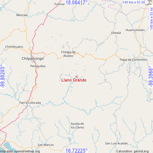
Llano Grande GPS coordinates[2]
17° 23' 39.984" North, 99° 5' 58.992" West
| Map corner | latitude | longitude |
|---|---|---|
| Upper-left | 18.06417°, | -99.80285° |
| Center: | 17.39444°, | -99.09972° |
| Lower-right: | 16.72225°, | -98.3966° |
| Map W x H: | 149.2×149.2 km | = 92.7×92.7mi |
| max Lat: | 32.7° ⇑84.2% North |
| Llano Grande: | 17.39444° |
| min Lat: | ⇓15.8% South 14.53588° |
| min Long | Llano Grande | max Long |
| -117.105° | -99.09972° | -86.73105° |
| W 48.9%⇐ | ⇒51.1% E |
Elevation
Elevation of Llano Grande is 690 m = 2264 ft, and this is 563.7 m = 1849 ft below average elevation for this country.
| Max E: |
3497 m = 11473 ft | 64.9% |
| Avg. | 1253.7 m = 4113 ft | |
| Llano Grande | 690 m = 2264 ft | |
Min E: |
-1 m = -3 ft | 35.1% |
See also: Mexico elevation on elevation.city.
Geographical zone
Llano Grande is located in North Torrid zone (between Equator and Tropic of Cancer). Distance of this Northern Tropic circle is 671.8 km =417.4 mi to North.| Distance of | km | miles | from Llano Grande |
|---|---|---|---|
| North Pole | 8073 | 5016.3 | to North |
| Arctic Circle | 5467.1 | 3397.1 | to North |
| Tropic Cancer | 671.8 | 417.4 | to North |
| Equator | 1934.1 | 1201.8 | to South |


Nearby cities:
15 places around Llano Grande: (largest is in red/bold)
• Ayahualtempa
9.7 km =6 mi,  43°
43°
• Colotlipa
7.4 km =4.6 mi,  285°
285°
• El Epazote
5.7 km =3.5 mi,  121°
121°
• Hueycantenango
10 km =6.2 mi,  52°
52°
• Jocutla
7 km =4.3 mi,  215°
215°
• Juxtlahuaca
6.3 km =3.9 mi,  307°
307°
• Mexcalcingo
10.7 km =6.6 mi,  95°
95°
• Nanzintla
6.6 km =4.1 mi,  178°
178°
• Popocatzin
8.6 km =5.3 mi, 103°
• Santa Fe
10.5 km =6.5 mi,  281°
281°
• Tlalchichiltipán Nuevo
10.6 km =6.6 mi,  87°
87°
• Tlalixtlahuacán
10.3 km =6.4 mi,  348°
348°
• Tlanicuilulco
0.8 km =0.5 mi,  226°
226°
• Xiloxuchicán
10.7 km =6.6 mi,  324°
324°
• Zelocotitlán
5.8 km =3.6 mi, 353°
Sources, notices
• [Note1] Compared only with cities in Mexico existing in our database
• [Src1] Map data: © OpenStreetMap contributors (CC-BY-SA)
• [Src2] Other city data from geonames.org with taken over terms of usage.
• [Src3] Geographical zone / Annual Mean Temperature by Robert A. Rohde @ Wikipedia
