El Ocotal geodata
El Ocotal (Hidalgo) is a populated place; located in Mexico in America/Mexico_City (GMT-6) time zone. With population of 642 people, there are 13481 cities with bigger population in this country. Compared to other cities in Mexico, 65.6% of cities are located further ↓South; 62.5% of cities are located further ←West and 56.5% of cities have higher elevation than El Ocotal. Note1


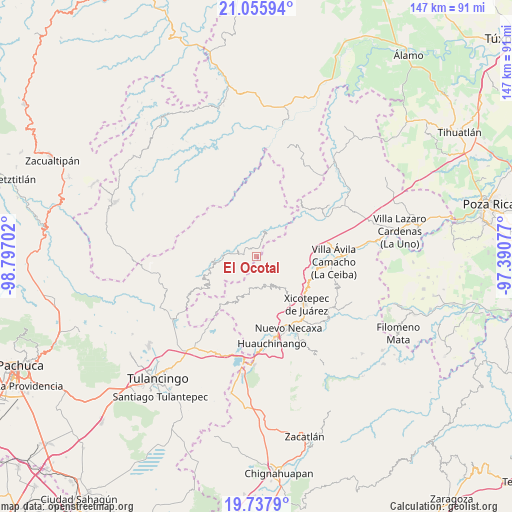
El Ocotal GPS coordinates[2]
20° 23' 53.988" North, 98° 5' 38.004" West
| Map corner | latitude | longitude |
|---|---|---|
| Upper-left | 21.05594°, | -98.79702° |
| Center: | 20.39833°, | -98.09389° |
| Lower-right: | 19.7379°, | -97.39077° |
| Map W x H: | 146.6×146.6 km | = 91.1×91.1mi |
| max Lat: | 32.7° ⇑34.4% North |
| El Ocotal: | 20.39833° |
| min Lat: | ⇓65.6% South 14.53588° |
| min Long | El Ocotal | max Long |
| -117.105° | -98.09389° | -86.73105° |
| W 62.5%⇐ | ⇒37.5% E |
Elevation
Elevation of El Ocotal is 1137 m = 3730 ft, and this is 116.7 m = 383 ft below average elevation for this country.
| Max E: |
3497 m = 11473 ft | 56.5% |
| Avg. | 1253.7 m = 4113 ft | |
| El Ocotal | 1137 m = 3730 ft | |
Min E: |
-1 m = -3 ft | 43.5% |
See also: Mexico elevation on elevation.city.
Geographical zone
El Ocotal is located in North Torrid zone (between Equator and Tropic of Cancer). Distance of this Northern Tropic circle is 337.8 km =209.9 mi to North.| Distance of | km | miles | from El Ocotal |
|---|---|---|---|
| North Pole | 7739 | 4808.8 | to North |
| Arctic Circle | 5133.1 | 3189.6 | to North |
| Tropic Cancer | 337.8 | 209.9 | to North |
| Equator | 2268.1 | 1409.3 | to South |


Nearby cities:
15 places around El Ocotal: (largest is in red/bold)
• Acalapa
9.3 km =5.8 mi,  179°
179°
• Acalmán
4.4 km =2.7 mi,  54°
54°
• Barrio Aztlán
7.5 km =4.7 mi,  6°
6°
• Cuauneutla de la Paz
9.4 km =5.8 mi,  185°
185°
• Cuautepec
8.5 km =5.3 mi,  140°
140°
• Cuaxtla
3.6 km =2.2 mi, 141°
• El Álamo
6.1 km =3.8 mi,  116°
116°
• Huehuetla
7.2 km =4.5 mi, 14°
• San Antonio el Grande
9 km =5.6 mi,  43°
43°
• San Clemente
5.6 km =3.5 mi,  277°
277°
• San Pablo el Grande
8 km =5 mi,  239°
239°
• Santa Inés
6.4 km =4 mi,  2°
2°
• Santa Úrsula
2.7 km =1.7 mi,  335°
335°
• Tlacuilotepec
8.5 km =5.3 mi,  161°
161°
• Tlaxco
7.3 km =4.5 mi,  67°
67°
Sources, notices
• [Note1] Compared only with cities in Mexico existing in our database
• [Src1] Map data: © OpenStreetMap contributors (CC-BY-SA)
• [Src2] Other city data from geonames.org with taken over terms of usage.
• [Src3] Geographical zone / Annual Mean Temperature by Robert A. Rohde @ Wikipedia
