Atlixtac geodata
Atlixtac (Guerrero) is a populated place; located in Mexico in America/Mexico_City (GMT-6) time zone. With population of 966 people, there are 9007 cities with bigger population in this country. Compared to other cities in Mexico, 76.2% of cities are located further ↑North; 59.9% of cities are located further →East and 66.7% of cities have higher elevation than Atlixtac. Note1


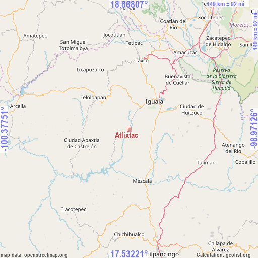
Atlixtac GPS coordinates[2]
18° 12' 5.112" North, 99° 40' 27.768" West
| Map corner | latitude | longitude |
|---|---|---|
| Upper-left | 18.86807°, | -100.37751° |
| Center: | 18.20142°, | -99.67438° |
| Lower-right: | 17.53221°, | -98.97126° |
| Map W x H: | 148.5×148.5 km | = 92.3×92.3mi |
| max Lat: | 32.7° ⇑76.2% North |
| Atlixtac: | 18.20142° |
| min Lat: | ⇓23.8% South 14.53588° |
| min Long | Atlixtac | max Long |
| -117.105° | -99.67438° | -86.73105° |
| W 40.1%⇐ | ⇒59.9% E |
Elevation
Elevation of Atlixtac is 603 m = 1978 ft, and this is 650.7 m = 2135 ft below average elevation for this country.
| Max E: |
3497 m = 11473 ft | 66.7% |
| Avg. | 1253.7 m = 4113 ft | |
| Atlixtac | 603 m = 1978 ft | |
Min E: |
-1 m = -3 ft | 33.3% |
See also: Mexico elevation on elevation.city.
Geographical zone
Atlixtac is located in North Torrid zone (between Equator and Tropic of Cancer). Distance of this Northern Tropic circle is 582.1 km =361.7 mi to North.| Distance of | km | miles | from Atlixtac |
|---|---|---|---|
| North Pole | 7983.3 | 4960.6 | to North |
| Arctic Circle | 5377.4 | 3341.4 | to North |
| Tropic Cancer | 582.1 | 361.7 | to North |
| Equator | 2023.8 | 1257.5 | to South |


Nearby cities:
15 places around Atlixtac: (largest is in red/bold)
• Ahuaxotitla
12.9 km =8 mi,  241°
241°
• Ahuehuepan
15.7 km =9.8 mi,  9°
9°
• Apango
3.8 km =2.4 mi,  353°
353°
• Apetlanca
12.1 km =7.5 mi,  273°
273°
• Apipilulco
1.2 km =0.7 mi,  167°
167°
• Chilacachapa
12.3 km =7.6 mi,  311°
311°
• Coacoyula de Álvarez
14.7 km =9.1 mi,  161°
161°
• Cocula
4.6 km =2.9 mi,  16°
16°
• Metlapa
13.9 km =8.6 mi,  29°
29°
• Sabana Grande
14.1 km =8.8 mi,  110°
110°
• Sasamulco
11.5 km =7.1 mi, 114°
• Tecuexcontitlán (Tecoescontitlán)
12.1 km =7.5 mi,  122°
122°
• Tianquizolco
8.8 km =5.5 mi,  285°
285°
• Tlacuitlapa
14.6 km =9.1 mi, 346°
• Tlanipatlán
9.1 km =5.7 mi, 238°
Sources, notices
• [Note1] Compared only with cities in Mexico existing in our database
• [Src1] Map data: © OpenStreetMap contributors (CC-BY-SA)
• [Src2] Other city data from geonames.org with taken over terms of usage.
• [Src3] Geographical zone / Annual Mean Temperature by Robert A. Rohde @ Wikipedia
