Zapotitlán geodata
Zapotitlán (Puebla) is a populated place; located in Mexico in America/Mexico_City (GMT-6) time zone. With population of 1,747 people, there are 4969 cities with bigger population in this country. Compared to other cities in Mexico, 57% of cities are located further ↓South; 67.1% of cities are located further ←West and 65.4% of cities have higher elevation than Zapotitlán. Note1


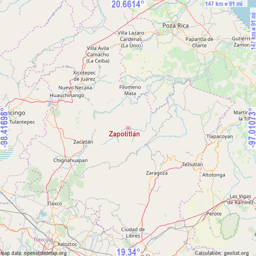
Zapotitlán GPS coordinates[2]
20° 0' 7.524" North, 97° 42' 49.86" West
| Map corner | latitude | longitude |
|---|---|---|
| Upper-left | 20.6614°, | -98.41698° |
| Center: | 20.00209°, | -97.71385° |
| Lower-right: | 19.34°, | -97.01073° |
| Map W x H: | 146.9×146.9 km | = 91.3×91.3mi |
| max Lat: | 32.7° ⇑43% North |
| Zapotitlán: | 20.00209° |
| min Lat: | ⇓57% South 14.53588° |
| min Long | Zapotitlán | max Long |
| -117.105° | -97.71385° | -86.73105° |
| W 67.1%⇐ | ⇒32.9% E |
Elevation
Elevation of Zapotitlán is 667 m = 2188 ft, and this is 586.7 m = 1925 ft below average elevation for this country.
| Max E: |
3497 m = 11473 ft | 65.4% |
| Avg. | 1253.7 m = 4113 ft | |
| Zapotitlán | 667 m = 2188 ft | |
Min E: |
-1 m = -3 ft | 34.6% |
See also: Mexico elevation on elevation.city.
Geographical zone
Zapotitlán is located in North Torrid zone (between Equator and Tropic of Cancer). Distance of this Northern Tropic circle is 381.9 km =237.3 mi to North.| Distance of | km | miles | from Zapotitlán |
|---|---|---|---|
| North Pole | 7783 | 4836.1 | to North |
| Arctic Circle | 5177.2 | 3217 | to North |
| Tropic Cancer | 381.9 | 237.3 | to North |
| Equator | 2224 | 1381.9 | to South |


Nearby cities:
15 places around Zapotitlán: (largest is in red/bold)
• Camocuautla
6.1 km =3.8 mi,  310°
310°
• Chipahuatlán
7.1 km =4.4 mi,  21°
21°
• Coatepec
6.8 km =4.2 mi,  344°
344°
• Cuarta Sección
3.9 km =2.4 mi,  144°
144°
• Huapalegcan
7.3 km =4.5 mi, 138°
• Hueytlalpan
3.3 km =2.1 mi,  32°
32°
• Huitzilan
4.3 km =2.7 mi,  152°
152°
• Nanacatlán
4 km =2.5 mi,  87°
87°
• Primera Sección
5 km =3.1 mi, 153°
• San Miguel del Progreso
5.1 km =3.2 mi,  105°
105°
• Tapayula
3.6 km =2.2 mi,  299°
299°
• Tenepanigia (Santa Elena)
7.3 km =4.5 mi,  236°
236°
• Tuxtla
6.1 km =3.8 mi, 91°
• Zitlala
6 km =3.7 mi,  52°
52°
• Zongozotla
2.9 km =1.8 mi,  209°
209°
Sources, notices
• [Note1] Compared only with cities in Mexico existing in our database
• [Src1] Map data: © OpenStreetMap contributors (CC-BY-SA)
• [Src2] Other city data from geonames.org with taken over terms of usage.
• [Src3] Geographical zone / Annual Mean Temperature by Robert A. Rohde @ Wikipedia
