Zongozotla geodata
Zongozotla (Puebla) is a seat of a second-order administrative division; located in Mexico in America/Mexico_City (GMT-6) time zone. With population of 4,266 people, there are 2150 cities with bigger population in this country. Compared to other cities in Mexico, 56.6% of cities are located further ↓South; 66.9% of cities are located further ←West and 56.7% of cities have higher elevation than Zongozotla. Note1


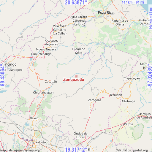
Zongozotla GPS coordinates[2]
19° 58' 45.48" North, 97° 43' 39.036" West
| Map corner | latitude | longitude |
|---|---|---|
| Upper-left | 20.63871°, | -98.43064° |
| Center: | 19.9793°, | -97.72751° |
| Lower-right: | 19.31712°, | -97.02439° |
| Map W x H: | 146.9×146.9 km | = 91.3×91.3mi |
| max Lat: | 32.7° ⇑43.4% North |
| Zongozotla: | 19.9793° |
| min Lat: | ⇓56.6% South 14.53588° |
| min Long | Zongozotla | max Long |
| -117.105° | -97.72751° | -86.73105° |
| W 66.9%⇐ | ⇒33.1% E |
Elevation
Elevation of Zongozotla is 1129 m = 3704 ft, and this is 124.7 m = 409 ft below average elevation for this country.
| Max E: |
3497 m = 11473 ft | 56.7% |
| Avg. | 1253.7 m = 4113 ft | |
| Zongozotla | 1129 m = 3704 ft | |
Min E: |
-1 m = -3 ft | 43.3% |
See also: Mexico elevation on elevation.city.
Geographical zone
Zongozotla is located in North Torrid zone (between Equator and Tropic of Cancer). Distance of this Northern Tropic circle is 384.4 km =238.9 mi to North.| Distance of | km | miles | from Zongozotla |
|---|---|---|---|
| North Pole | 7785.6 | 4837.7 | to North |
| Arctic Circle | 5179.7 | 3218.5 | to North |
| Tropic Cancer | 384.4 | 238.9 | to North |
| Equator | 2221.5 | 1380.4 | to South |


Nearby cities:
15 places around Zongozotla: (largest is in red/bold)
• Camocuautla
7.3 km =4.5 mi,  333°
333°
• Cuarta Sección
3.7 km =2.3 mi,  99°
99°
• Huapalegcan
6.9 km =4.3 mi,  115°
115°
• Hueytlalpan
6.2 km =3.9 mi,  31°
31°
• Huitzilan
3.7 km =2.3 mi,  110°
110°
• Nanacatlán
6 km =3.7 mi,  63°
63°
• Pahuatla
7.4 km =4.6 mi,  125°
125°
• Primera Sección
4.1 km =2.5 mi, 117°
• San Miguel del Progreso
6.5 km =4 mi,  79°
79°
• Tapayula
4.7 km =2.9 mi,  338°
338°
• Tenepanigia (Santa Elena)
4.9 km =3 mi,  252°
252°
• Tepango
7.7 km =4.8 mi,  290°
290°
• Tlapacholoya
7.6 km =4.7 mi,  236°
236°
• Zapotitlán
2.9 km =1.8 mi, 29°
• Zoyotla
6.7 km =4.2 mi,  148°
148°
Sources, notices
• [Note1] Compared only with cities in Mexico existing in our database
• [Src1] Map data: © OpenStreetMap contributors (CC-BY-SA)
• [Src2] Other city data from geonames.org with taken over terms of usage.
• [Src3] Geographical zone / Annual Mean Temperature by Robert A. Rohde @ Wikipedia
