Xicotlán geodata
Xicotlán (Puebla) is a seat of a second-order administrative division; located in Mexico in America/Mexico_City (GMT-6) time zone. With population of 706 people, there are 12320 cities with bigger population in this country. Compared to other cities in Mexico, 78% of cities are located further ↑North; 56.9% of cities are located further ←West and 53.3% of cities have higher elevation than Xicotlán. Note1


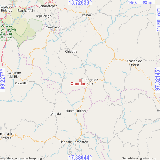
Xicotlán GPS coordinates[2]
18° 3' 33.048" North, 98° 31' 28.452" West
| Map corner | latitude | longitude |
|---|---|---|
| Upper-left | 18.72638°, | -99.2277° |
| Center: | 18.05918°, | -98.52457° |
| Lower-right: | 17.38944°, | -97.82145° |
| Map W x H: | 148.7×148.7 km | = 92.4×92.4mi |
| max Lat: | 32.7° ⇑78% North |
| Xicotlán: | 18.05918° |
| min Lat: | ⇓22% South 14.53588° |
| min Long | Xicotlán | max Long |
| -117.105° | -98.52457° | -86.73105° |
| W 56.9%⇐ | ⇒43.1% E |
Elevation
Elevation of Xicotlán is 1279 m = 4196 ft, and this is 25.3 m = 83 ft above average elevation for this country.
| Max E: |
3497 m = 11473 ft | 53.3% |
| Xicotlán | 1279 m 4196 ft | |
| Avg. | 1253.7 m = 4113 ft | |
Min E: |
-1 m = -3 ft | 46.7% |
See also: Mexico elevation on elevation.city.
Geographical zone
Xicotlán is located in North Torrid zone (between Equator and Tropic of Cancer). Distance of this Northern Tropic circle is 597.9 km =371.5 mi to North.| Distance of | km | miles | from Xicotlán |
|---|---|---|---|
| North Pole | 7999.1 | 4970.4 | to North |
| Arctic Circle | 5393.2 | 3351.2 | to North |
| Tropic Cancer | 597.9 | 371.5 | to North |
| Equator | 2008 | 1247.7 | to South |


Nearby cities:
15 places around Xicotlán: (largest is in red/bold)
• Acaxtlahuacán de Albino Zertuche
5 km =3.1 mi,  199°
199°
• Axutla
20.3 km =12.6 mi,  44°
44°
• Chila de la Sal
7 km =4.3 mi, 36°
• Coacalco
15.2 km =9.4 mi,  275°
275°
• Guadalupe Victoria
17.2 km =10.7 mi,  121°
121°
• Ixcamilpa
18.5 km =11.5 mi,  259°
259°
• Progreso
22.7 km =14.1 mi,  96°
96°
• San Miguel Comitlipa
10.8 km =6.7 mi, 195°
• San Miguel Tlaltepexi
19.3 km =12 mi,  146°
146°
• Santa Cruz Lomalapa (Lomalapa)
22.3 km =13.9 mi,  224°
224°
• Toltecamila
14.7 km =9.1 mi, 222°
• Tulcingo de Valle
9 km =5.6 mi, 100°
• Xixingo de los Reyes
22.2 km =13.8 mi, 145°
• Xochihuehuetlán
17.4 km =10.8 mi,  167°
167°
• Zumpango
21.7 km =13.5 mi,  230°
230°
Sources, notices
• [Note1] Compared only with cities in Mexico existing in our database
• [Src1] Map data: © OpenStreetMap contributors (CC-BY-SA)
• [Src2] Other city data from geonames.org with taken over terms of usage.
• [Src3] Geographical zone / Annual Mean Temperature by Robert A. Rohde @ Wikipedia
