Ayotzinapa geodata
Ayotzinapa (Guerrero) is a populated place; located in Mexico in America/Mexico_City (GMT-6) time zone. With population of 673 people, there are 12911 cities with bigger population in this country. Compared to other cities in Mexico, 81.2% of cities are located further ↑North; 53.4% of cities are located further →East and 56.7% of cities have lower elevation than Ayotzinapa. Note1


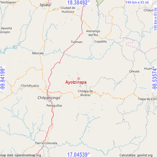
Ayotzinapa GPS coordinates[2]
17° 42' 59.076" North, 99° 14' 19.896" West
| Map corner | latitude | longitude |
|---|---|---|
| Upper-left | 18.38492°, | -99.94199° |
| Center: | 17.71641°, | -99.23886° |
| Lower-right: | 17.04539°, | -98.53574° |
| Map W x H: | 148.9×148.9 km | = 92.5×92.5mi |
| max Lat: | 32.7° ⇑81.2% North |
| Ayotzinapa: | 17.71641° |
| min Lat: | ⇓18.8% South 14.53588° |
| min Long | Ayotzinapa | max Long |
| -117.105° | -99.23886° | -86.73105° |
| W 46.6%⇐ | ⇒53.4% E |
Elevation
Elevation of Ayotzinapa is 1648 m = 5407 ft, and this is 394.3 m = 1294 ft above average elevation for this country.
| Max E: |
3497 m = 11473 ft | 43.3% |
| Ayotzinapa | 1648 m 5407 ft | |
| Avg. | 1253.7 m = 4113 ft | |
Min E: |
-1 m = -3 ft | 56.7% |
See also: Mexico elevation on elevation.city.
Geographical zone
Ayotzinapa is located in North Torrid zone (between Equator and Tropic of Cancer). Distance of this Northern Tropic circle is 636 km =395.2 mi to North.| Distance of | km | miles | from Ayotzinapa |
|---|---|---|---|
| North Pole | 8037.2 | 4994.1 | to North |
| Arctic Circle | 5431.3 | 3374.9 | to North |
| Tropic Cancer | 636 | 395.2 | to North |
| Equator | 1969.9 | 1224 | to South |


Nearby cities:
15 places around Ayotzinapa: (largest is in red/bold)
• Acatlán
9.8 km =6.1 mi,  131°
131°
• Ahuihuiyuco
9.7 km =6 mi,  172°
172°
• Apango
9.9 km =6.2 mi,  286°
286°
• Hueyitlalpan
7.5 km =4.7 mi,  232°
232°
• La Esperanza
5 km =3.1 mi,  349°
349°
• La Mohonera
9.5 km =5.9 mi,  155°
155°
• Las Trancas
1.9 km =1.2 mi, 127°
• Mazatepec
6.2 km =3.9 mi, 158°
• Pochahuizco
6 km =3.7 mi, 163°
• Rancho de las Lomas
2.7 km =1.7 mi,  344°
344°
• Tepozcuautla
10.5 km =6.5 mi, 173°
• Tlaltempanapa
6.9 km =4.3 mi,  71°
71°
• Topiltepec
7.5 km =4.7 mi, 166°
• Zitlala
6.3 km =3.9 mi,  117°
117°
• Zotoltitlán
5.6 km =3.5 mi,  267°
267°
Sources, notices
• [Note1] Compared only with cities in Mexico existing in our database
• [Src1] Map data: © OpenStreetMap contributors (CC-BY-SA)
• [Src2] Other city data from geonames.org with taken over terms of usage.
• [Src3] Geographical zone / Annual Mean Temperature by Robert A. Rohde @ Wikipedia
