Zotoltitlán geodata
Zotoltitlán (Guerrero) is a populated place; located in Mexico in America/Mexico_City (GMT-6) time zone. With population of 2,247 people, there are 3913 cities with bigger population in this country. Compared to other cities in Mexico, 81.2% of cities are located further ↑North; 54.1% of cities are located further →East and 55.3% of cities have lower elevation than Zotoltitlán. Note1


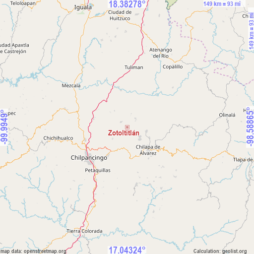
Zotoltitlán GPS coordinates[2]
17° 42' 51.336" North, 99° 17' 30.372" West
| Map corner | latitude | longitude |
|---|---|---|
| Upper-left | 18.38278°, | -99.9949° |
| Center: | 17.71426°, | -99.29177° |
| Lower-right: | 17.04324°, | -98.58865° |
| Map W x H: | 148.9×148.9 km | = 92.5×92.5mi |
| max Lat: | 32.7° ⇑81.2% North |
| Zotoltitlán: | 17.71426° |
| min Lat: | ⇓18.8% South 14.53588° |
| min Long | Zotoltitlán | max Long |
| -117.105° | -99.29177° | -86.73105° |
| W 45.9%⇐ | ⇒54.1% E |
Elevation
Elevation of Zotoltitlán is 1596 m = 5236 ft, and this is 342.3 m = 1123 ft above average elevation for this country.
| Max E: |
3497 m = 11473 ft | 44.7% |
| Zotoltitlán | 1596 m 5236 ft | |
| Avg. | 1253.7 m = 4113 ft | |
Min E: |
-1 m = -3 ft | 55.3% |
See also: Mexico elevation on elevation.city.
Geographical zone
Zotoltitlán is located in North Torrid zone (between Equator and Tropic of Cancer). Distance of this Northern Tropic circle is 636.3 km =395.4 mi to North.| Distance of | km | miles | from Zotoltitlán |
|---|---|---|---|
| North Pole | 8037.4 | 4994.2 | to North |
| Arctic Circle | 5431.5 | 3375 | to North |
| Tropic Cancer | 636.3 | 395.4 | to North |
| Equator | 1969.6 | 1223.9 | to South |


Nearby cities:
15 places around Zotoltitlán: (largest is in red/bold)
• Acatempa
11.2 km =7 mi,  225°
225°
• Ahuihuiyuco
11.6 km =7.2 mi,  144°
144°
• Almolonga
8.5 km =5.3 mi,  182°
182°
• Apango
5 km =3.1 mi,  307°
307°
• Atliaca
11.2 km =7 mi, 231°
• Ayotzinapa
5.6 km =3.5 mi,  87°
87°
• Hueyitlalpan
4.4 km =2.7 mi,  185°
185°
• La Esperanza
7 km =4.3 mi,  42°
42°
• Las Trancas
7.2 km =4.5 mi,  97°
97°
• Mazatepec
9.6 km =6 mi,  125°
125°
• Pochahuizco
9.2 km =5.7 mi, 127°
• Rancho de las Lomas
5.6 km =3.5 mi,  59°
59°
• Tepozcuautla
12.3 km =7.6 mi,  146°
146°
• Topiltepec
10.2 km =6.3 mi, 134°
• Zitlala
11.5 km =7.1 mi, 103°
Sources, notices
• [Note1] Compared only with cities in Mexico existing in our database
• [Src1] Map data: © OpenStreetMap contributors (CC-BY-SA)
• [Src2] Other city data from geonames.org with taken over terms of usage.
• [Src3] Geographical zone / Annual Mean Temperature by Robert A. Rohde @ Wikipedia
