San Lorenzo Tlalmimilolpan geodata
San Lorenzo Tlalmimilolpan (State of Mexico) is a populated place; located in Mexico in America/Mexico_City (GMT-6) time zone. With population of 2,725 people, there are 3241 cities with bigger population in this country. Compared to other cities in Mexico, 60.6% of cities are located further ↑North; 53.5% of cities are located further ←West and 89.1% of cities have lower elevation than San Lorenzo Tlalmimilolpan. Note1
Current local time in San Lorenzo Tlalmimilolpan:
12:58 AM, WednesdayDifference from your time zone: hours


San Lorenzo Tlalmimilolpan GPS coordinates[2]
19° 13' 16.248" North, 98° 48' 17.46" West
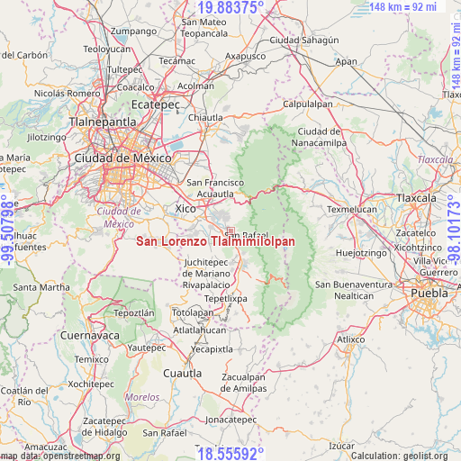
| Map corner | latitude | longitude |
|---|---|---|
| Upper-left | 19.88375°, | -99.50798° |
| Center: | 19.22118°, | -98.80485° |
| Lower-right: | 18.55592°, | -98.10173° |
| Map W x H: | 147.6×147.6 km | = 91.7×91.7mi |
| max Lat: | 32.7° ⇑60.6% North |
| San Lorenzo Tlalmimilolpan: | 19.22118° |
| min Lat: | ⇓39.4% South 14.53588° |
| min Long | San Lorenzo Tla | max Long |
| -117.105° | -98.80485° | -86.73105° |
| W 53.5%⇐ | ⇒46.5% E |
Elevation
Elevation of San Lorenzo Tlalmimilolpan is 2375 m = 7792 ft, and this is 1121.3 m = 3679 ft above average elevation for this country.
| Max E: |
3497 m = 11473 ft | 10.9% |
| San Lorenzo Tlalmimilolpan | 2375 m 7792 ft | |
| Avg. | 1253.7 m = 4113 ft | |
Min E: |
-1 m = -3 ft | 89.1% |
See also: Mexico elevation on elevation.city.
Geographical zone
San Lorenzo Tlalmimilolpan is located in North Torrid zone (between Equator and Tropic of Cancer). Distance of this Northern Tropic circle is 468.7 km =291.2 mi to North.| Distance of | km | miles | from San Lorenzo Tlalmimilolpan |
|---|---|---|---|
| North Pole | 7869.9 | 4890.1 | to North |
| Arctic Circle | 5264 | 3270.9 | to North |
| Tropic Cancer | 468.7 | 291.2 | to North |
| Equator | 2137.2 | 1328 | to South |


Nearby cities:
15 places around San Lorenzo Tlalmimilolpan: (largest is in red/bold)
• Cocotitlán
6.6 km =4.1 mi,  281°
281°
• Ejido Atoyac
4.7 km =2.9 mi, 277°
• El Cabi
6.2 km =3.9 mi,  235°
235°
• Ex-Hacienda de Guadalupe
5.1 km =3.2 mi,  303°
303°
• La Candelaria Tlapala
5 km =3.1 mi, 295°
• Miraflores
0.3 km =0.2 mi,  290°
290°
• San Andrés Metla
3.9 km =2.4 mi,  263°
263°
• San Antonio Tlaltecahuacán
8 km =5 mi,  151°
151°
• San Gregorio Cuautzingo
7 km =4.3 mi,  307°
307°
• San Martín Cuautlalpan
6.7 km =4.2 mi,  335°
335°
• San Rafael
5.3 km =3.3 mi,  104°
104°
• Santa María Huexoculco
4.4 km =2.7 mi, 338°
• Santo Tomás Atzingo
6 km =3.7 mi, 153°
• Temamatla
7.1 km =4.4 mi,  253°
253°
• Tlalmanalco
1.8 km =1.1 mi,  167°
167°
Sources, notices
• [Note1] Compared only with cities in Mexico existing in our database
• [Src1] Map data: © OpenStreetMap contributors (CC-BY-SA)
• [Src2] Other city data from geonames.org with taken over terms of usage.
• [Src3] Geographical zone / Annual Mean Temperature by Robert A. Rohde @ Wikipedia
