Miraflores geodata
Miraflores (State of Mexico) is a populated place; located in Mexico in America/Mexico_City (GMT-6) time zone. With population of 9,904 people, there are 964 cities with bigger population in this country. Compared to other cities in Mexico, 60.6% of cities are located further ↑North; 53.5% of cities are located further ←West and 87.5% of cities have lower elevation than Miraflores. Note1


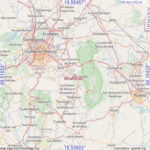
Miraflores GPS coordinates[2]
19° 13' 19.56" North, 98° 48' 26.676" West
| Map corner | latitude | longitude |
|---|---|---|
| Upper-left | 19.88467°, | -99.51054° |
| Center: | 19.2221°, | -98.80741° |
| Lower-right: | 18.55685°, | -98.10429° |
| Map W x H: | 147.6×147.6 km | = 91.7×91.7mi |
| max Lat: | 32.7° ⇑60.6% North |
| Miraflores: | 19.2221° |
| min Lat: | ⇓39.4% South 14.53588° |
| min Long | Miraflores | max Long |
| -117.105° | -98.80741° | -86.73105° |
| W 53.5%⇐ | ⇒46.5% E |
Elevation
Elevation of Miraflores is 2326 m = 7631 ft, and this is 1072.3 m = 3518 ft above average elevation for this country.
| Max E: |
3497 m = 11473 ft | 12.5% |
| Miraflores | 2326 m 7631 ft | |
| Avg. | 1253.7 m = 4113 ft | |
Min E: |
-1 m = -3 ft | 87.5% |
See also: Mexico elevation on elevation.city.
Geographical zone
Miraflores is located in North Torrid zone (between Equator and Tropic of Cancer). Distance of this Northern Tropic circle is 468.6 km =291.2 mi to North.| Distance of | km | miles | from Miraflores |
|---|---|---|---|
| North Pole | 7869.8 | 4890.1 | to North |
| Arctic Circle | 5263.9 | 3270.8 | to North |
| Tropic Cancer | 468.6 | 291.2 | to North |
| Equator | 2137.3 | 1328.1 | to South |


Nearby cities:
15 places around Miraflores: (largest is in red/bold)
• Cocotitlán
6.3 km =3.9 mi,  281°
281°
• Ejido Atoyac
4.4 km =2.7 mi, 276°
• El Cabi
6 km =3.7 mi,  233°
233°
• Ex-Hacienda de Guadalupe
4.8 km =3 mi,  304°
304°
• La Candelaria Tlapala
4.7 km =2.9 mi, 295°
• Los Reyes Acatlixhuayán
8 km =5 mi,  259°
259°
• San Andrés Metla
3.6 km =2.2 mi, 260°
• San Gregorio Cuautzingo
6.7 km =4.2 mi,  308°
308°
• San Lorenzo Tlalmimilolpan
0.3 km =0.2 mi,  110°
110°
• San Martín Cuautlalpan
6.5 km =4 mi,  337°
337°
• San Rafael
5.5 km =3.4 mi,  104°
104°
• Santa María Huexoculco
4.2 km =2.6 mi, 341°
• Santo Tomás Atzingo
6.3 km =3.9 mi,  151°
151°
• Temamatla
6.8 km =4.2 mi,  251°
251°
• Tlalmanalco
2 km =1.2 mi,  160°
160°
Sources, notices
• [Note1] Compared only with cities in Mexico existing in our database
• [Src1] Map data: © OpenStreetMap contributors (CC-BY-SA)
• [Src2] Other city data from geonames.org with taken over terms of usage.
• [Src3] Geographical zone / Annual Mean Temperature by Robert A. Rohde @ Wikipedia
