San Andrés Metla geodata
San Andrés Metla (State of Mexico) is a populated place; located in Mexico in America/Mexico_City (GMT-6) time zone. With population of 1,629 people, there are 5313 cities with bigger population in this country. Compared to other cities in Mexico, 60.8% of cities are located further ↑North; 53% of cities are located further ←West and 88.1% of cities have lower elevation than San Andrés Metla. Note1


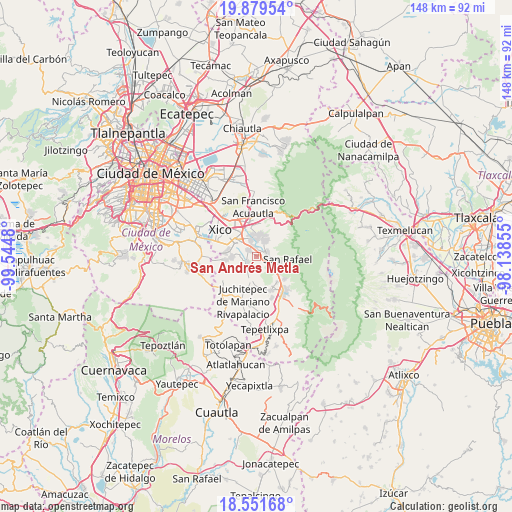
San Andrés Metla GPS coordinates[2]
19° 13' 1.02" North, 98° 50' 30.012" West
| Map corner | latitude | longitude |
|---|---|---|
| Upper-left | 19.87954°, | -99.5448° |
| Center: | 19.21695°, | -98.84167° |
| Lower-right: | 18.55168°, | -98.13855° |
| Map W x H: | 147.6×147.6 km | = 91.7×91.7mi |
| max Lat: | 32.7° ⇑60.8% North |
| San Andrés Metla: | 19.21695° |
| min Lat: | ⇓39.2% South 14.53588° |
| min Long | San Andrés Met | max Long |
| -117.105° | -98.84167° | -86.73105° |
| W 53%⇐ | ⇒47% E |
Elevation
Elevation of San Andrés Metla is 2345 m = 7694 ft, and this is 1091.3 m = 3580 ft above average elevation for this country.
| Max E: |
3497 m = 11473 ft | 11.9% |
| San Andrés Metla | 2345 m 7694 ft | |
| Avg. | 1253.7 m = 4113 ft | |
Min E: |
-1 m = -3 ft | 88.1% |
See also: Mexico elevation on elevation.city.
Geographical zone
San Andrés Metla is located in North Torrid zone (between Equator and Tropic of Cancer). Distance of this Northern Tropic circle is 469.2 km =291.5 mi to North.| Distance of | km | miles | from San Andrés Metla |
|---|---|---|---|
| North Pole | 7870.3 | 4890.4 | to North |
| Arctic Circle | 5264.4 | 3271.1 | to North |
| Tropic Cancer | 469.2 | 291.5 | to North |
| Equator | 2136.7 | 1327.7 | to South |


Nearby cities:
15 places around San Andrés Metla: (largest is in red/bold)
• Cocotitlán
3.1 km =1.9 mi,  305°
305°
• Colonia San José
6.1 km =3.8 mi,  260°
260°
• Ejido Atoyac
1.3 km =0.8 mi,  324°
324°
• El Cabi
3.3 km =2.1 mi,  202°
202°
• Ex-Hacienda de Guadalupe
3.3 km =2.1 mi,  353°
353°
• La Candelaria Tlapala
2.7 km =1.7 mi, 346°
• Los Reyes Acatlixhuayán
4.4 km =2.7 mi, 258°
• Miraflores
3.6 km =2.2 mi,  80°
80°
• San Gregorio Cuautzingo
5 km =3.1 mi,  340°
340°
• San Lorenzo Tlalmimilolpan
3.9 km =2.4 mi, 83°
• San Lucas Amalinalco
6.4 km =4 mi, 338°
• Santa María Huexoculco
5.1 km =3.2 mi,  25°
25°
• Temamatla
3.3 km =2.1 mi,  241°
241°
• Tlalmanalco
4.5 km =2.8 mi,  107°
107°
• Zula
5 km =3.1 mi,  274°
274°
Sources, notices
• [Note1] Compared only with cities in Mexico existing in our database
• [Src1] Map data: © OpenStreetMap contributors (CC-BY-SA)
• [Src2] Other city data from geonames.org with taken over terms of usage.
• [Src3] Geographical zone / Annual Mean Temperature by Robert A. Rohde @ Wikipedia
