El Álamo geodata
El Álamo (Puebla) is a populated place; located in Mexico in America/Mexico_City (GMT-6) time zone. With population of 761 people, there are 11509 cities with bigger population in this country. Compared to other cities in Mexico, 65.1% of cities are located further ↓South; 63.1% of cities are located further ←West and 58.4% of cities have higher elevation than El Álamo. Note1


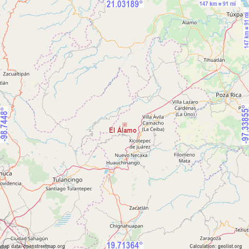
El Álamo GPS coordinates[2]
20° 22' 27.012" North, 98° 2' 30.012" West
| Map corner | latitude | longitude |
|---|---|---|
| Upper-left | 21.03189°, | -98.7448° |
| Center: | 20.37417°, | -98.04167° |
| Lower-right: | 19.71364°, | -97.33855° |
| Map W x H: | 146.6×146.6 km | = 91.1×91.1mi |
| max Lat: | 32.7° ⇑34.9% North |
| El Álamo: | 20.37417° |
| min Lat: | ⇓65.1% South 14.53588° |
| min Long | El Álamo | max Long |
| -117.105° | -98.04167° | -86.73105° |
| W 63.1%⇐ | ⇒36.9% E |
Elevation
Elevation of El Álamo is 1084 m = 3556 ft, and this is 169.7 m = 557 ft below average elevation for this country.
| Max E: |
3497 m = 11473 ft | 58.4% |
| Avg. | 1253.7 m = 4113 ft | |
| El Álamo | 1084 m = 3556 ft | |
Min E: |
-1 m = -3 ft | 41.6% |
See also: Mexico elevation on elevation.city.
Geographical zone
El Álamo is located in North Torrid zone (between Equator and Tropic of Cancer). Distance of this Northern Tropic circle is 340.5 km =211.6 mi to North.| Distance of | km | miles | from El Álamo |
|---|---|---|---|
| North Pole | 7741.7 | 4810.5 | to North |
| Arctic Circle | 5135.8 | 3191.2 | to North |
| Tropic Cancer | 340.5 | 211.6 | to North |
| Equator | 2265.4 | 1407.7 | to South |


Nearby cities:
15 places around El Álamo: (largest is in red/bold)
• Acalapa
8.5 km =5.3 mi,  218°
218°
• Acalmán
5.6 km =3.5 mi,  340°
340°
• Cuautepec
3.9 km =2.4 mi,  180°
180°
• Cuaxtla
3.2 km =2 mi,  267°
267°
• El Jericó
4.7 km =2.9 mi,  120°
120°
• El Ocotal
6.1 km =3.8 mi,  296°
296°
• El Rincón
7.7 km =4.8 mi,  28°
28°
• Itzatlán
7.4 km =4.6 mi,  126°
126°
• San Antonio el Grande
9.2 km =5.7 mi,  4°
4°
• Santa María
6.7 km =4.2 mi,  191°
191°
• Santa Úrsula
8.3 km =5.2 mi,  307°
307°
• Tlacuilotepec
6.1 km =3.8 mi,  207°
207°
• Tlapehuala
6.9 km =4.3 mi,  168°
168°
• Tlaxco
5.6 km =3.5 mi,  13°
13°
• Zacatal
6.3 km =3.9 mi,  94°
94°
Sources, notices
• [Note1] Compared only with cities in Mexico existing in our database
• [Src1] Map data: © OpenStreetMap contributors (CC-BY-SA)
• [Src2] Other city data from geonames.org with taken over terms of usage.
• [Src3] Geographical zone / Annual Mean Temperature by Robert A. Rohde @ Wikipedia
