Zoh-Laguna geodata
Zoh-Laguna (Campeche) is a populated place; located in Mexico in America/Cancun (GMT-5) time zone. With population of 1,074 people, there are 8122 cities with bigger population in this country. Compared to other cities in Mexico, 71.5% of cities are located further ↑North; 98.2% of cities are located further ←West and 73.4% of cities have higher elevation than Zoh-Laguna. Note1


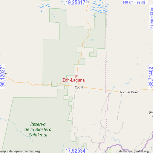
Zoh-Laguna GPS coordinates[2]
18° 35' 35.016" North, 89° 25' 1.704" West
| Map corner | latitude | longitude |
|---|---|---|
| Upper-left | 19.25817°, | -90.12027° |
| Center: | 18.59306°, | -89.41714° |
| Lower-right: | 17.92534°, | -88.71402° |
| Map W x H: | 148.2×148.2 km | = 92.1×92.1mi |
| max Lat: | 32.7° ⇑71.5% North |
| Zoh-Laguna: | 18.59306° |
| min Lat: | ⇓28.5% South 14.53588° |
| min Long | Zoh-Laguna | max Long |
| -117.105° | -89.41714° | -86.73105° |
| W 98.2%⇐ | ⇒1.8% E |
Elevation
Elevation of Zoh-Laguna is 275 m = 902 ft, and this is 978.7 m = 3211 ft below average elevation for this country.
| Max E: |
3497 m = 11473 ft | 73.4% |
| Avg. | 1253.7 m = 4113 ft | |
| Zoh-Laguna | 275 m = 902 ft | |
Min E: |
-1 m = -3 ft | 26.6% |
See also: Mexico elevation on elevation.city.
Geographical zone
Zoh-Laguna is located in North Torrid zone (between Equator and Tropic of Cancer). Distance of this Northern Tropic circle is 538.6 km =334.7 mi to North.| Distance of | km | miles | from Zoh-Laguna |
|---|---|---|---|
| North Pole | 7939.7 | 4933.5 | to North |
| Arctic Circle | 5333.8 | 3314.3 | to North |
| Tropic Cancer | 538.6 | 334.7 | to North |
| Equator | 2067.4 | 1284.6 | to South |


Nearby cities:
15 places around Zoh-Laguna: (largest is in red/bold)
• Caobas
36.8 km =22.9 mi,  116°
116°
• Francisco Villa
61.7 km =38.3 mi,  101°
101°
• Ingeniero Ricardo Payro Jene (Polo Norte)
30.8 km =19.1 mi,  185°
185°
• Lázaro Cárdenas Segundo
60.1 km =37.3 mi,  78°
78°
• Manuel Castilla Brito
26.1 km =16.2 mi, 185°
• Miguel Alemán
49.3 km =30.6 mi,  43°
43°
• Morocoy
63.9 km =39.7 mi,  88°
88°
• Nachi Cocom
71.3 km =44.3 mi, 99°
• Nicolás Bravo
53.7 km =33.4 mi,  106°
106°
• Nuevo Becar
33.5 km =20.8 mi,  64°
64°
• Nuevo Conhuás
53.6 km =33.3 mi,  263°
263°
• San Pedro Peralta
60.3 km =37.5 mi, 78°
• Santo Domingo
66.2 km =41.1 mi,  176°
176°
• Tres Garantías
63.9 km =39.7 mi,  134°
134°
• Xpujil
9.8 km =6.1 mi,  165°
165°
Sources, notices
• [Note1] Compared only with cities in Mexico existing in our database
• [Src1] Map data: © OpenStreetMap contributors (CC-BY-SA)
• [Src2] Other city data from geonames.org with taken over terms of usage.
• [Src3] Geographical zone / Annual Mean Temperature by Robert A. Rohde @ Wikipedia
