Miguel Alemán geodata
Miguel Alemán (Quintana Roo) is a populated place; located in Mexico in America/Cancun (GMT-5) time zone. With population of 688 people, there are 12631 cities with bigger population in this country. Compared to other cities in Mexico, 66.7% of cities are located further ↑North; 98.7% of cities are located further ←West and 80.3% of cities have higher elevation than Miguel Alemán. Note1


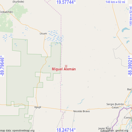
Miguel Alemán GPS coordinates[2]
18° 54' 48.996" North, 89° 5' 35.988" West
| Map corner | latitude | longitude |
|---|---|---|
| Upper-left | 19.57744°, | -89.79646° |
| Center: | 18.91361°, | -89.09333° |
| Lower-right: | 18.24714°, | -88.39021° |
| Map W x H: | 147.9×147.9 km | = 91.9×91.9mi |
| max Lat: | 32.7° ⇑66.7% North |
| Miguel Alemán: | 18.91361° |
| min Lat: | ⇓33.3% South 14.53588° |
| min Long | Miguel Alemán | max Long |
| -117.105° | -89.09333° | -86.73105° |
| W 98.7%⇐ | ⇒1.3% E |
Elevation
Elevation of Miguel Alemán is 90 m = 295 ft, and this is 1163.7 m = 3818 ft below average elevation for this country.
| Max E: |
3497 m = 11473 ft | 80.3% |
| Avg. | 1253.7 m = 4113 ft | |
| Miguel Alemán | 90 m = 295 ft | |
Min E: |
-1 m = -3 ft | 19.7% |
See also: Mexico elevation on elevation.city.
Geographical zone
Miguel Alemán is located in North Torrid zone (between Equator and Tropic of Cancer). Distance of this Northern Tropic circle is 502.9 km =312.5 mi to North.| Distance of | km | miles | from Miguel Alemán |
|---|---|---|---|
| North Pole | 7904.1 | 4911.4 | to North |
| Arctic Circle | 5298.2 | 3292.1 | to North |
| Tropic Cancer | 502.9 | 312.5 | to North |
| Equator | 2103 | 1306.7 | to South |


Nearby cities:
15 places around Miguel Alemán: (largest is in red/bold)
• Altos de Sevilla
44.3 km =27.5 mi,  98°
98°
• Caobas
52.1 km =32.4 mi,  181°
181°
• Francisco Villa
55.1 km =34.2 mi,  151°
151°
• Lázaro Cárdenas Segundo
34.2 km =21.3 mi,  133°
133°
• Morocoy
45.5 km =28.3 mi,  139°
139°
• Nachi Cocom
59.9 km =37.2 mi, 143°
• Nicolás Bravo
53.5 km =33.2 mi,  160°
160°
• Nuevo Becar
21.4 km =13.3 mi,  190°
190°
• Reforma
55.9 km =34.7 mi, 101°
• San Pedro Peralta
34.4 km =21.4 mi, 133°
• San Román
40.7 km =25.3 mi,  109°
109°
• Ukúm
44.5 km =27.7 mi,  325°
325°
• Xmabén
42.6 km =26.5 mi, 327°
• Xpujil
55.2 km =34.3 mi,  215°
215°
• Zoh-Laguna
49.3 km =30.6 mi, 223°
Sources, notices
• [Note1] Compared only with cities in Mexico existing in our database
• [Src1] Map data: © OpenStreetMap contributors (CC-BY-SA)
• [Src2] Other city data from geonames.org with taken over terms of usage.
• [Src3] Geographical zone / Annual Mean Temperature by Robert A. Rohde @ Wikipedia
