Cuaxilotla geodata
Cuaxilotla (Guerrero) is a populated place; located in Mexico in America/Mexico_City (GMT-6) time zone. With population of 540 people, there are 15727 cities with bigger population in this country. Compared to other cities in Mexico, 76.5% of cities are located further ↑North; 62.1% of cities are located further →East and 55.4% of cities have higher elevation than Cuaxilotla. Note1


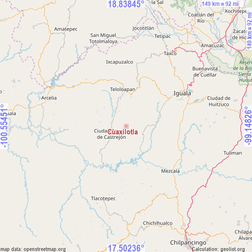
Cuaxilotla GPS coordinates[2]
18° 10' 18.048" North, 99° 51' 4.968" West
| Map corner | latitude | longitude |
|---|---|---|
| Upper-left | 18.83845°, | -100.55451° |
| Center: | 18.17168°, | -99.85138° |
| Lower-right: | 17.50236°, | -99.14826° |
| Map W x H: | 148.6×148.6 km | = 92.3×92.3mi |
| max Lat: | 32.7° ⇑76.5% North |
| Cuaxilotla: | 18.17168° |
| min Lat: | ⇓23.5% South 14.53588° |
| min Long | Cuaxilotla | max Long |
| -117.105° | -99.85138° | -86.73105° |
| W 37.9%⇐ | ⇒62.1% E |
Elevation
Elevation of Cuaxilotla is 1184 m = 3885 ft, and this is 69.7 m = 229 ft below average elevation for this country.
| Max E: |
3497 m = 11473 ft | 55.4% |
| Avg. | 1253.7 m = 4113 ft | |
| Cuaxilotla | 1184 m = 3885 ft | |
Min E: |
-1 m = -3 ft | 44.6% |
See also: Mexico elevation on elevation.city.
Geographical zone
Cuaxilotla is located in North Torrid zone (between Equator and Tropic of Cancer). Distance of this Northern Tropic circle is 585.4 km =363.8 mi to North.| Distance of | km | miles | from Cuaxilotla |
|---|---|---|---|
| North Pole | 7986.6 | 4962.6 | to North |
| Arctic Circle | 5380.7 | 3343.4 | to North |
| Tropic Cancer | 585.4 | 363.8 | to North |
| Equator | 2020.5 | 1255.5 | to South |


Nearby cities:
15 places around Cuaxilotla: (largest is in red/bold)
• Acatempan
16.6 km =10.3 mi,  348°
348°
• Ahuaxotitla
7.8 km =4.8 mi,  110°
110°
• Apaxtla de Castrejón
9.7 km =6 mi,  242°
242°
• Apetlanca
7.8 km =4.8 mi,  58°
58°
• Atlixtac
19 km =11.8 mi,  79°
79°
• Chilacachapa
14.8 km =9.2 mi,  39°
39°
• Cuetzala del Progreso
4.6 km =2.9 mi,  153°
153°
• El Calvario
13.7 km =8.5 mi,  16°
16°
• Los Sauces
10.7 km =6.6 mi,  9°
9°
• Nuevo Balsas
18.3 km =11.4 mi, 147°
• Oxtotitlán
8.8 km =5.5 mi,  283°
283°
• Tehuixtla
18.3 km =11.4 mi,  331°
331°
• Tianquizolco
11.7 km =7.3 mi, 60°
• Tlacaquipa
6.5 km =4 mi,  340°
340°
• Tlanipatlán
11 km =6.8 mi,  97°
97°
Sources, notices
• [Note1] Compared only with cities in Mexico existing in our database
• [Src1] Map data: © OpenStreetMap contributors (CC-BY-SA)
• [Src2] Other city data from geonames.org with taken over terms of usage.
• [Src3] Geographical zone / Annual Mean Temperature by Robert A. Rohde @ Wikipedia
