Acatlán del Río geodata
Acatlán del Río (Guerrero) is a populated place; located in Mexico in America/Mexico_City (GMT-6) time zone. With population of 514 people, there are 16370 cities with bigger population in this country. Compared to other cities in Mexico, 79.3% of cities are located further ↑North; 62.6% of cities are located further →East and 68.6% of cities have higher elevation than Acatlán del Río. Note1


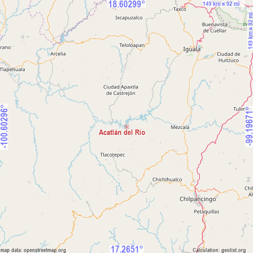
Acatlán del Río GPS coordinates[2]
17° 56' 7.116" North, 99° 53' 59.388" West
| Map corner | latitude | longitude |
|---|---|---|
| Upper-left | 18.60299°, | -100.60296° |
| Center: | 17.93531°, | -99.89983° |
| Lower-right: | 17.2651°, | -99.19671° |
| Map W x H: | 148.8×148.8 km | = 92.5×92.5mi |
| max Lat: | 32.7° ⇑79.3% North |
| Acatlán del Río: | 17.93531° |
| min Lat: | ⇓20.7% South 14.53588° |
| min Long | Acatlán del R� | max Long |
| -117.105° | -99.89983° | -86.73105° |
| W 37.4%⇐ | ⇒62.6% E |
Elevation
Elevation of Acatlán del Río is 492 m = 1614 ft, and this is 761.7 m = 2499 ft below average elevation for this country.
| Max E: |
3497 m = 11473 ft | 68.6% |
| Avg. | 1253.7 m = 4113 ft | |
| Acatlán del Río | 492 m = 1614 ft | |
Min E: |
-1 m = -3 ft | 31.4% |
See also: Mexico elevation on elevation.city.
Geographical zone
Acatlán del Río is located in North Torrid zone (between Equator and Tropic of Cancer). Distance of this Northern Tropic circle is 611.7 km =380.1 mi to North.| Distance of | km | miles | from Acatlán del Río |
|---|---|---|---|
| North Pole | 8012.8 | 4978.9 | to North |
| Arctic Circle | 5407 | 3359.8 | to North |
| Tropic Cancer | 611.7 | 380.1 | to North |
| Equator | 1994.2 | 1239.1 | to South |


Nearby cities:
15 places around Acatlán del Río: (largest is in red/bold)
• Apaxtla de Castrejón
22.1 km =13.7 mi,  350°
350°
• Atzcala
25.5 km =15.8 mi,  79°
79°
• Carrizalillo
21.9 km =13.6 mi,  115°
115°
• Chichiltepec
22.5 km =14 mi,  230°
230°
• Cuetzala del Progreso
23.3 km =14.5 mi,  17°
17°
• Huautla
23.4 km =14.5 mi,  246°
246°
• La Ciénega
13.3 km =8.3 mi,  168°
168°
• La Venta
14 km =8.7 mi,  182°
182°
• Las Vinatas
9.8 km =6.1 mi,  148°
148°
• Nuevo Balsas
18.4 km =11.4 mi,  54°
54°
• Nuevo Poblado el Caracol
13.2 km =8.2 mi,  281°
281°
• Tlacotenco
17.4 km =10.8 mi,  190°
190°
• Tlacotepec
18.3 km =11.4 mi,  207°
207°
• Zompantle
22.8 km =14.2 mi, 211°
• Zopilostoc
23.8 km =14.8 mi,  204°
204°
Sources, notices
• [Note1] Compared only with cities in Mexico existing in our database
• [Src1] Map data: © OpenStreetMap contributors (CC-BY-SA)
• [Src2] Other city data from geonames.org with taken over terms of usage.
• [Src3] Geographical zone / Annual Mean Temperature by Robert A. Rohde @ Wikipedia
