Las Vinatas geodata
Las Vinatas (Guerrero) is a populated place; located in Mexico in America/Mexico_City (GMT-6) time zone. With population of 565 people, there are 15122 cities with bigger population in this country. Compared to other cities in Mexico, 80% of cities are located further ↑North; 62.1% of cities are located further →East and 51.6% of cities have higher elevation than Las Vinatas. Note1


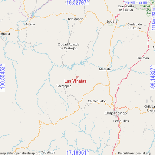
Las Vinatas GPS coordinates[2]
17° 51' 36" North, 99° 51' 5.004" West
| Map corner | latitude | longitude |
|---|---|---|
| Upper-left | 18.52797°, | -100.55452° |
| Center: | 17.86°, | -99.85139° |
| Lower-right: | 17.18951°, | -99.14827° |
| Map W x H: | 148.8×148.8 km | = 92.5×92.5mi |
| max Lat: | 32.7° ⇑80% North |
| Las Vinatas: | 17.86° |
| min Lat: | ⇓20% South 14.53588° |
| min Long | Las Vinatas | max Long |
| -117.105° | -99.85139° | -86.73105° |
| W 37.9%⇐ | ⇒62.1% E |
Elevation
Elevation of Las Vinatas is 1356 m = 4449 ft, and this is 102.3 m = 336 ft above average elevation for this country.
| Max E: |
3497 m = 11473 ft | 51.6% |
| Las Vinatas | 1356 m 4449 ft | |
| Avg. | 1253.7 m = 4113 ft | |
Min E: |
-1 m = -3 ft | 48.4% |
See also: Mexico elevation on elevation.city.
Geographical zone
Las Vinatas is located in North Torrid zone (between Equator and Tropic of Cancer). Distance of this Northern Tropic circle is 620.1 km =385.3 mi to North.| Distance of | km | miles | from Las Vinatas |
|---|---|---|---|
| North Pole | 8021.2 | 4984.1 | to North |
| Arctic Circle | 5415.3 | 3364.9 | to North |
| Tropic Cancer | 620.1 | 385.3 | to North |
| Equator | 1985.8 | 1233.9 | to South |


Nearby cities:
15 places around Las Vinatas: (largest is in red/bold)
• Acatlán del Río
9.8 km =6.1 mi,  328°
328°
• Campo de Aviación
22.7 km =14.1 mi,  171°
171°
• Carrizalillo
14.7 km =9.1 mi,  93°
93°
• El Naranjo
20.8 km =12.9 mi,  147°
147°
• Huerta Vieja
22.2 km =13.8 mi,  206°
206°
• La Ciénega
5.3 km =3.3 mi, 208°
• La Venta
8.1 km =5 mi,  226°
226°
• Nuevo Balsas
21.5 km =13.4 mi,  26°
26°
• Nuevo Poblado el Caracol
21.2 km =13.2 mi,  301°
301°
• Puerto del Varal
19.8 km =12.3 mi, 211°
• Tlacotenco
12.1 km =7.5 mi,  223°
223°
• Tlacotepec
15.7 km =9.8 mi,  240°
240°
• Xochipala
23 km =14.3 mi,  103°
103°
• Zompantle
20.4 km =12.7 mi, 237°
• Zopilostoc
20 km =12.4 mi, 228°
Sources, notices
• [Note1] Compared only with cities in Mexico existing in our database
• [Src1] Map data: © OpenStreetMap contributors (CC-BY-SA)
• [Src2] Other city data from geonames.org with taken over terms of usage.
• [Src3] Geographical zone / Annual Mean Temperature by Robert A. Rohde @ Wikipedia
