Amojileca geodata
Amojileca (Guerrero) is a populated place; located in Mexico in America/Mexico_City (GMT-6) time zone. With population of 971 people, there are 8951 cities with bigger population in this country. Compared to other cities in Mexico, 82.4% of cities are located further ↑North; 57.9% of cities are located further →East and 51.1% of cities have lower elevation than Amojileca. Note1


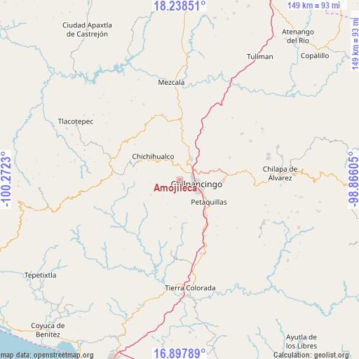
Amojileca GPS coordinates[2]
17° 34' 9.984" North, 99° 34' 9.012" West
| Map corner | latitude | longitude |
|---|---|---|
| Upper-left | 18.23851°, | -100.2723° |
| Center: | 17.56944°, | -99.56917° |
| Lower-right: | 16.89789°, | -98.86605° |
| Map W x H: | 149.1×149.1 km | = 92.6×92.6mi |
| max Lat: | 32.7° ⇑82.4% North |
| Amojileca: | 17.56944° |
| min Lat: | ⇓17.6% South 14.53588° |
| min Long | Amojileca | max Long |
| -117.105° | -99.56917° | -86.73105° |
| W 42.1%⇐ | ⇒57.9% E |
Elevation
Elevation of Amojileca is 1489 m = 4885 ft, and this is 235.3 m = 772 ft above average elevation for this country.
| Max E: |
3497 m = 11473 ft | 48.9% |
| Amojileca | 1489 m 4885 ft | |
| Avg. | 1253.7 m = 4113 ft | |
Min E: |
-1 m = -3 ft | 51.1% |
See also: Mexico elevation on elevation.city.
Geographical zone
Amojileca is located in North Torrid zone (between Equator and Tropic of Cancer). Distance of this Northern Tropic circle is 652.4 km =405.4 mi to North.| Distance of | km | miles | from Amojileca |
|---|---|---|---|
| North Pole | 8053.5 | 5004.2 | to North |
| Arctic Circle | 5447.6 | 3385 | to North |
| Tropic Cancer | 652.4 | 405.4 | to North |
| Equator | 1953.5 | 1213.8 | to South |


Nearby cities:
15 places around Amojileca: (largest is in red/bold)
• Atlixtac
10.6 km =6.6 mi,  321°
321°
• Chichihualco
15.1 km =9.4 mi,  311°
311°
• Chilpancingo
7 km =4.3 mi,  107°
107°
• El Fresno
15.4 km =9.6 mi,  186°
186°
• El Palmar
9.6 km =6 mi,  338°
338°
• Iyotla
19.8 km =12.3 mi,  287°
287°
• La Esperanza
20.5 km =12.7 mi, 191°
• Mazatlán
18.5 km =11.5 mi,  143°
143°
• Palo Blanco
21.4 km =13.3 mi,  149°
149°
• Petaquillas
15.1 km =9.4 mi,  127°
127°
• San Vicente
13.6 km =8.5 mi,  243°
243°
• Tepechicotlán
18.9 km =11.7 mi,  120°
120°
• Tepozonalco
18.5 km =11.5 mi,  281°
281°
• Tixtla de Guerrero
18.1 km =11.2 mi,  90°
90°
• Zumpango del Río
10.4 km =6.5 mi,  25°
25°
Sources, notices
• [Note1] Compared only with cities in Mexico existing in our database
• [Src1] Map data: © OpenStreetMap contributors (CC-BY-SA)
• [Src2] Other city data from geonames.org with taken over terms of usage.
• [Src3] Geographical zone / Annual Mean Temperature by Robert A. Rohde @ Wikipedia
