Zoyatlán geodata
Zoyatlán (Guerrero) is a populated place; located in Mexico in America/Mexico_City (GMT-6) time zone. With population of 1,119 people, there are 7761 cities with bigger population in this country. Compared to other cities in Mexico, 92.8% of cities are located further ↑North; 54.6% of cities are located further ←West and 76.7% of cities have higher elevation than Zoyatlán. Note1


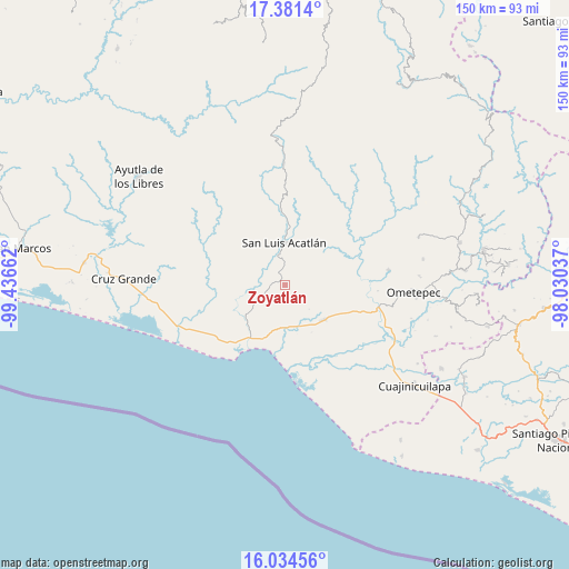
Zoyatlán GPS coordinates[2]
16° 42' 33.012" North, 98° 44' 0.564" West
| Map corner | latitude | longitude |
|---|---|---|
| Upper-left | 17.3814°, | -99.43662° |
| Center: | 16.70917°, | -98.73349° |
| Lower-right: | 16.03456°, | -98.03037° |
| Map W x H: | 149.8×149.8 km | = 93.1×93.1mi |
| max Lat: | 32.7° ⇑92.8% North |
| Zoyatlán: | 16.70917° |
| min Lat: | ⇓7.2% South 14.53588° |
| min Long | Zoyatlán | max Long |
| -117.105° | -98.73349° | -86.73105° |
| W 54.6%⇐ | ⇒45.4% E |
Elevation
Elevation of Zoyatlán is 160 m = 525 ft, and this is 1093.7 m = 3588 ft below average elevation for this country.
| Max E: |
3497 m = 11473 ft | 76.7% |
| Avg. | 1253.7 m = 4113 ft | |
| Zoyatlán | 160 m = 525 ft | |
Min E: |
-1 m = -3 ft | 23.3% |
See also: Mexico elevation on elevation.city.
Geographical zone
Zoyatlán is located in North Torrid zone (between Equator and Tropic of Cancer). Distance of this Northern Tropic circle is 748 km =464.8 mi to North.| Distance of | km | miles | from Zoyatlán |
|---|---|---|---|
| North Pole | 8149.2 | 5063.7 | to North |
| Arctic Circle | 5543.3 | 3444.4 | to North |
| Tropic Cancer | 748 | 464.8 | to North |
| Equator | 1857.9 | 1154.4 | to South |


Nearby cities:
15 places around Zoyatlán: (largest is in red/bold)
• Agua Zarca
10.1 km =6.3 mi,  160°
160°
• Arcelia de Rodríguez
9.9 km =6.2 mi,  72°
72°
• Azoyú
14.3 km =8.9 mi,  79°
79°
• Carrizalillo
11.6 km =7.2 mi,  195°
195°
• Cuanacaxtitlán
14.1 km =8.8 mi,  44°
44°
• El Capulín Chocolate
5.6 km =3.5 mi,  209°
209°
• El Carmen
11.9 km =7.4 mi,  347°
347°
• Jolotichán
4.8 km =3 mi,  3°
3°
• Juchitán
13.7 km =8.5 mi,  133°
133°
• Miahuichán
13.2 km =8.2 mi,  322°
322°
• San Isidro el Puente (El Puente)
12.8 km =8 mi,  117°
117°
• San Luis Acatlán
11.1 km =6.9 mi, 0°
• Tepantitlán
13.5 km =8.4 mi,  229°
229°
• Yoloxóchitl
12.9 km =8 mi,  22°
22°
• Zapotitlán de la Fuente (El Zapote)
12 km =7.5 mi, 79°
Sources, notices
• [Note1] Compared only with cities in Mexico existing in our database
• [Src1] Map data: © OpenStreetMap contributors (CC-BY-SA)
• [Src2] Other city data from geonames.org with taken over terms of usage.
• [Src3] Geographical zone / Annual Mean Temperature by Robert A. Rohde @ Wikipedia
