Agua Zarca geodata
Agua Zarca (Guerrero) is a populated place; located in Mexico in America/Mexico_City (GMT-6) time zone. With population of 1,149 people, there are 7545 cities with bigger population in this country. Compared to other cities in Mexico, 93.5% of cities are located further ↑North; 55.1% of cities are located further ←West and 76.5% of cities have higher elevation than Agua Zarca. Note1


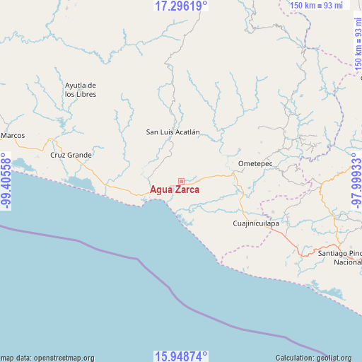
Agua Zarca GPS coordinates[2]
16° 37' 25.14" North, 98° 42' 8.82" West
| Map corner | latitude | longitude |
|---|---|---|
| Upper-left | 17.29619°, | -99.40558° |
| Center: | 16.62365°, | -98.70245° |
| Lower-right: | 15.94874°, | -97.99933° |
| Map W x H: | 149.8×149.8 km | = 93.1×93.1mi |
| max Lat: | 32.7° ⇑93.5% North |
| Agua Zarca: | 16.62365° |
| min Lat: | ⇓6.5% South 14.53588° |
| min Long | Agua Zarca | max Long |
| -117.105° | -98.70245° | -86.73105° |
| W 55.1%⇐ | ⇒44.9% E |
Elevation
Elevation of Agua Zarca is 168 m = 551 ft, and this is 1085.7 m = 3562 ft below average elevation for this country.
| Max E: |
3497 m = 11473 ft | 76.5% |
| Avg. | 1253.7 m = 4113 ft | |
| Agua Zarca | 168 m = 551 ft | |
Min E: |
-1 m = -3 ft | 23.5% |
See also: Mexico elevation on elevation.city.
Geographical zone
Agua Zarca is located in North Torrid zone (between Equator and Tropic of Cancer). Distance of this Northern Tropic circle is 757.5 km =470.7 mi to North.| Distance of | km | miles | from Agua Zarca |
|---|---|---|---|
| North Pole | 8158.7 | 5069.6 | to North |
| Arctic Circle | 5552.8 | 3450.3 | to North |
| Tropic Cancer | 757.5 | 470.7 | to North |
| Equator | 1848.4 | 1148.5 | to South |


Nearby cities:
15 places around Agua Zarca: (largest is in red/bold)
• Arcelia de Rodríguez
14 km =8.7 mi,  26°
26°
• Azoyú
16.2 km =10.1 mi,  41°
41°
• Barra de Tecoanapa
13.2 km =8.2 mi,  193°
193°
• Carrizalillo
6.7 km =4.2 mi,  255°
255°
• El Capulín Chocolate
7.7 km =4.8 mi,  307°
307°
• El Polvorín
11.7 km =7.3 mi,  244°
244°
• Huehuetán
15.4 km =9.6 mi,  84°
84°
• Islaltepec (Las Parotas)
15.5 km =9.6 mi,  250°
250°
• Jolotichán
14.6 km =9.1 mi,  348°
348°
• Juchitán
6.6 km =4.1 mi,  89°
89°
• Marquelia
13 km =8.1 mi, 249°
• San Isidro el Puente (El Puente)
8.8 km =5.5 mi,  66°
66°
• Tepantitlán
13.6 km =8.5 mi,  273°
273°
• Zapotitlán de la Fuente (El Zapote)
14.4 km =8.9 mi, 36°
• Zoyatlán
10.1 km =6.3 mi,  340°
340°
Sources, notices
• [Note1] Compared only with cities in Mexico existing in our database
• [Src1] Map data: © OpenStreetMap contributors (CC-BY-SA)
• [Src2] Other city data from geonames.org with taken over terms of usage.
• [Src3] Geographical zone / Annual Mean Temperature by Robert A. Rohde @ Wikipedia
