Estación Chavarrillo geodata
Estación Chavarrillo (Veracruz) is a populated place; located in Mexico in America/Mexico_City (GMT-6) time zone. With population of 594 people, there are 14476 cities with bigger population in this country. Compared to other cities in Mexico, 55.6% of cities are located further ↑North; 77.1% of cities are located further ←West and 61.8% of cities have higher elevation than Estación Chavarrillo. Note1
Current local time in Estación Chavarrillo:
05:06 AM, WednesdayDifference from your time zone: hours


Estación Chavarrillo GPS coordinates[2]
19° 25' 41.988" North, 96° 48' 33.768" West
| Map corner | latitude | longitude |
|---|---|---|
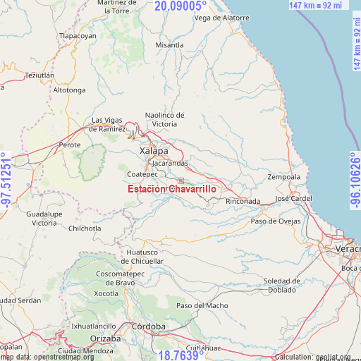
| Upper-left | 20.09005°, | -97.51251° |
| Center: | 19.42833°, | -96.80938° |
| Lower-right: | 18.7639°, | -96.10626° |
| Map W x H: | 147.5×147.5 km | = 91.7×91.7mi |
| max Lat: | 32.7° ⇑55.6% North |
| Estación Chavarrillo: | 19.42833° |
| min Lat: | ⇓44.4% South 14.53588° |
| min Long | Estación Chava | max Long |
| -117.105° | -96.80938° | -86.73105° |
| W 77.1%⇐ | ⇒22.9% E |
Elevation
Elevation of Estación Chavarrillo is 891 m = 2923 ft, and this is 362.7 m = 1190 ft below average elevation for this country.
| Max E: |
3497 m = 11473 ft | 61.8% |
| Avg. | 1253.7 m = 4113 ft | |
| Estación Chavarrillo | 891 m = 2923 ft | |
Min E: |
-1 m = -3 ft | 38.2% |
See also: Mexico elevation on elevation.city.
Geographical zone
Estación Chavarrillo is located in North Torrid zone (between Equator and Tropic of Cancer). Distance of this Northern Tropic circle is 445.7 km =276.9 mi to North.| Distance of | km | miles | from Estación Chavarrillo |
|---|---|---|---|
| North Pole | 7846.8 | 4875.8 | to North |
| Arctic Circle | 5240.9 | 3256.5 | to North |
| Tropic Cancer | 445.7 | 276.9 | to North |
| Equator | 2160.2 | 1342.3 | to South |


Nearby cities:
15 places around Estación Chavarrillo: (largest is in red/bold)
• Alborada
6.8 km =4.2 mi,  289°
289°
• Bella Esperanza
6 km =3.7 mi,  275°
275°
• Chavarrillo
1.6 km =1 mi,  101°
101°
• Colonia la Perseverancia
9.7 km =6 mi,  320°
320°
• Dos Ríos
6.3 km =3.9 mi,  9°
9°
• El Chico
5 km =3.1 mi,  325°
325°
• El Lencero
6.8 km =4.2 mi,  353°
353°
• El Roble
8.1 km =5 mi, 103°
• Estanzuela
6.3 km =3.9 mi,  305°
305°
• Jacarandas
8.8 km =5.5 mi, 328°
• Lomas de Miradores
4.3 km =2.7 mi,  34°
34°
• Pacho Nuevo
9 km =5.6 mi, 306°
• Pinoltepec
5.9 km =3.7 mi,  75°
75°
• Rancho Viejo
3.4 km =2.1 mi,  58°
58°
• Tuzamapan
6.4 km =4 mi,  243°
243°
Sources, notices
• [Note1] Compared only with cities in Mexico existing in our database
• [Src1] Map data: © OpenStreetMap contributors (CC-BY-SA)
• [Src2] Other city data from geonames.org with taken over terms of usage.
• [Src3] Geographical zone / Annual Mean Temperature by Robert A. Rohde @ Wikipedia
