Chahuatlán geodata
Chahuatlán (Veracruz) is a populated place; located in Mexico in America/Mexico_City (GMT-6) time zone. With population of 903 people, there are 9658 cities with bigger population in this country. Compared to other cities in Mexico, 73% of cities are located further ↓South; 58.7% of cities are located further ←West and 71.1% of cities have higher elevation than Chahuatlán. Note1


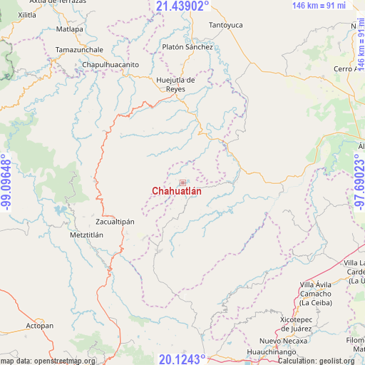
Chahuatlán GPS coordinates[2]
20° 46' 59.124" North, 98° 23' 36.06" West
| Map corner | latitude | longitude |
|---|---|---|
| Upper-left | 21.43902°, | -99.09648° |
| Center: | 20.78309°, | -98.39335° |
| Lower-right: | 20.1243°, | -97.69023° |
| Map W x H: | 146.2×146.2 km | = 90.8×90.8mi |
| max Lat: | 32.7° ⇑27% North |
| Chahuatlán: | 20.78309° |
| min Lat: | ⇓73% South 14.53588° |
| min Long | Chahuatlán | max Long |
| -117.105° | -98.39335° | -86.73105° |
| W 58.7%⇐ | ⇒41.3% E |
Elevation
Elevation of Chahuatlán is 368 m = 1207 ft, and this is 885.7 m = 2906 ft below average elevation for this country.
| Max E: |
3497 m = 11473 ft | 71.1% |
| Avg. | 1253.7 m = 4113 ft | |
| Chahuatlán | 368 m = 1207 ft | |
Min E: |
-1 m = -3 ft | 28.9% |
See also: Mexico elevation on elevation.city.
Geographical zone
Chahuatlán is located in North Torrid zone (between Equator and Tropic of Cancer). Distance of this Northern Tropic circle is 295.1 km =183.4 mi to North.| Distance of | km | miles | from Chahuatlán |
|---|---|---|---|
| North Pole | 7696.2 | 4782.2 | to North |
| Arctic Circle | 5090.3 | 3163 | to North |
| Tropic Cancer | 295.1 | 183.4 | to North |
| Equator | 2310.9 | 1435.9 | to South |


Nearby cities:
15 places around Chahuatlán: (largest is in red/bold)
• Aguacatitla
9.4 km =5.8 mi,  337°
337°
• Arnatepec
1.9 km =1.2 mi,  304°
304°
• Atempa
3.9 km =2.4 mi,  217°
217°
• Coacoaco
6.7 km =4.2 mi,  317°
317°
• Huitztipan
6.7 km =4.2 mi,  27°
27°
• Ilamatlán
5.2 km =3.2 mi,  266°
266°
• José María Pino Suárez
4.8 km =3 mi,  180°
180°
• La Candelaria
7.2 km =4.5 mi,  104°
104°
• Pachiquita
9.3 km =5.8 mi,  40°
40°
• San Gregorio
4.1 km =2.5 mi,  3°
3°
• Santa Cruz
3.1 km =1.9 mi, 298°
• Tecapa
9.1 km =5.7 mi,  232°
232°
• Tlatlazoquico
5.7 km =3.5 mi, 42°
• Xococapa
5.3 km =3.3 mi,  56°
56°
• Zontecomatlán de López y Fuentes
5.7 km =3.5 mi,  113°
113°
Sources, notices
• [Note1] Compared only with cities in Mexico existing in our database
• [Src1] Map data: © OpenStreetMap contributors (CC-BY-SA)
• [Src2] Other city data from geonames.org with taken over terms of usage.
• [Src3] Geographical zone / Annual Mean Temperature by Robert A. Rohde @ Wikipedia
