Palma Sola geodata
Palma Sola (Veracruz) is a populated place; located in Mexico in America/Mexico_City (GMT-6) time zone. With population of 3,144 people, there are 2871 cities with bigger population in this country. Compared to other cities in Mexico, 52% of cities are located further ↓South; 80.1% of cities are located further ←West and 94.6% of cities have higher elevation than Palma Sola. Note1


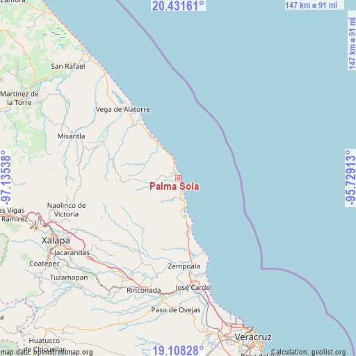
Palma Sola GPS coordinates[2]
19° 46' 16.752" North, 96° 25' 56.1" West
| Map corner | latitude | longitude |
|---|---|---|
| Upper-left | 20.43161°, | -97.13538° |
| Center: | 19.77132°, | -96.43225° |
| Lower-right: | 19.10828°, | -95.72913° |
| Map W x H: | 147.1×147.1 km | = 91.4×91.4mi |
| max Lat: | 32.7° ⇑48% North |
| Palma Sola: | 19.77132° |
| min Lat: | ⇓52% South 14.53588° |
| min Long | Palma Sola | max Long |
| -117.105° | -96.43225° | -86.73105° |
| W 80.1%⇐ | ⇒19.9% E |
Elevation
Elevation of Palma Sola is 14 m = 46 ft, and this is 1239.7 m = 4067 ft below average elevation for this country.
| Max E: |
3497 m = 11473 ft | 94.6% |
| Avg. | 1253.7 m = 4113 ft | |
| Palma Sola | 14 m = 46 ft | |
Min E: |
-1 m = -3 ft | 5.4% |
See also: Mexico elevation on elevation.city.
Geographical zone
Palma Sola is located in North Torrid zone (between Equator and Tropic of Cancer). Distance of this Northern Tropic circle is 407.6 km =253.3 mi to North.| Distance of | km | miles | from Palma Sola |
|---|---|---|---|
| North Pole | 7808.7 | 4852.1 | to North |
| Arctic Circle | 5202.8 | 3232.9 | to North |
| Tropic Cancer | 407.6 | 253.3 | to North |
| Equator | 2198.4 | 1366 | to South |


Nearby cities:
15 places around Palma Sola: (largest is in red/bold)
• El Chaparral
25.4 km =15.8 mi,  295°
295°
• El Farallón
15.1 km =9.4 mi,  171°
171°
• El Viejón Nuevo
9.5 km =5.9 mi, 166°
• Juchique de Ferrer
28.5 km =17.7 mi,  285°
285°
• La Reforma
28.6 km =17.8 mi,  227°
227°
• Laguna de Farfán
22.4 km =13.9 mi,  279°
279°
• Monte Verde Chivería
28.6 km =17.8 mi,  254°
254°
• Palmas de Abajo
20.2 km =12.6 mi,  181°
181°
• Plan de las Hayas
25.5 km =15.8 mi,  267°
267°
• Rancho Nuevo
25.7 km =16 mi,  259°
259°
• San José Pastorías
27.2 km =16.9 mi,  212°
212°
• Santa Ana
15.4 km =9.6 mi,  329°
329°
• Tierra Blanca
26.1 km =16.2 mi, 257°
• Tinajitas
17.1 km =10.6 mi, 183°
• Zoyacuautla
26.5 km =16.5 mi,  215°
215°
Sources, notices
• [Note1] Compared only with cities in Mexico existing in our database
• [Src1] Map data: © OpenStreetMap contributors (CC-BY-SA)
• [Src2] Other city data from geonames.org with taken over terms of usage.
• [Src3] Geographical zone / Annual Mean Temperature by Robert A. Rohde @ Wikipedia
