Cieneguilla geodata
Cieneguilla (Zacatecas) is a populated place; located in Mexico in America/Mexico_City (GMT-6) time zone. With population of 715 people, there are 12184 cities with bigger population in this country. Compared to other cities in Mexico, 85.2% of cities are located further ↓South; 76.8% of cities are located further →East and 81.2% of cities have lower elevation than Cieneguilla. Note1


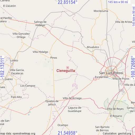
Cieneguilla GPS coordinates[2]
22° 12' 7.452" North, 101° 25' 47.928" West
| Map corner | latitude | longitude |
|---|---|---|
| Upper-left | 22.85154°, | -102.13311° |
| Center: | 22.20207°, | -101.42998° |
| Lower-right: | 21.54958°, | -100.72686° |
| Map W x H: | 144.8×144.8 km | = 90×90mi |
| max Lat: | 32.7° ⇑14.8% North |
| Cieneguilla: | 22.20207° |
| min Lat: | ⇓85.2% South 14.53588° |
| min Long | Cieneguilla | max Long |
| -117.105° | -101.42998° | -86.73105° |
| W 23.2%⇐ | ⇒76.8% E |
Elevation
Elevation of Cieneguilla is 2169 m = 7116 ft, and this is 915.3 m = 3003 ft above average elevation for this country.
| Max E: |
3497 m = 11473 ft | 18.8% |
| Cieneguilla | 2169 m 7116 ft | |
| Avg. | 1253.7 m = 4113 ft | |
Min E: |
-1 m = -3 ft | 81.2% |
See also: Mexico elevation on elevation.city.
Geographical zone
Cieneguilla is located in North Torrid zone (between Equator and Tropic of Cancer). Distance of this Northern Tropic circle is 137.3 km =85.3 mi to North.| Distance of | km | miles | from Cieneguilla |
|---|---|---|---|
| North Pole | 7538.4 | 4684.1 | to North |
| Arctic Circle | 4932.5 | 3064.9 | to North |
| Tropic Cancer | 137.3 | 85.3 | to North |
| Equator | 2468.6 | 1533.9 | to South |


Nearby cities:
15 places around Cieneguilla: (largest is in red/bold)
• Ahijaderos
19.2 km =11.9 mi,  346°
346°
• El Obraje
16.7 km =10.4 mi,  261°
261°
• Guadalupe de los Sauces
17.5 km =10.9 mi, 354°
• José María Morelos
12.1 km =7.5 mi,  234°
234°
• La Blanca (Chihuahua)
19.3 km =12 mi, 225°
• La Estrella
13.9 km =8.6 mi,  202°
202°
• La Tapona
21.3 km =13.2 mi,  82°
82°
• La Victoria
21.4 km =13.3 mi,  286°
286°
• Paso Bonito
22.1 km =13.7 mi,  51°
51°
• Pinos
18.3 km =11.4 mi,  304°
304°
• Saldaña
22 km =13.7 mi,  7°
7°
• San José de Castellanos
16.2 km =10.1 mi, 230°
• San Luis Gonzaga
20.5 km =12.7 mi,  136°
136°
• San Martín
6 km =3.7 mi,  66°
66°
• Santa Ana
21.6 km =13.4 mi, 347°
Sources, notices
• [Note1] Compared only with cities in Mexico existing in our database
• [Src1] Map data: © OpenStreetMap contributors (CC-BY-SA)
• [Src2] Other city data from geonames.org with taken over terms of usage.
• [Src3] Geographical zone / Annual Mean Temperature by Robert A. Rohde @ Wikipedia
