Guadalupe de los Sauces geodata
Guadalupe de los Sauces (Zacatecas) is a populated place; located in Mexico in America/Mexico_City (GMT-6) time zone. With population of 518 people, there are 16254 cities with bigger population in this country. Compared to other cities in Mexico, 86% of cities are located further ↓South; 76.9% of cities are located further →East and 86.5% of cities have lower elevation than Guadalupe de los Sauces. Note1
Current local time in Guadalupe de los Sauces:
10:29 AM, MondayDifference from your time zone: hours


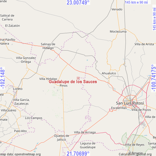
Guadalupe de los Sauces GPS coordinates[2]
22° 21' 31.536" North, 101° 26' 41.532" West
| Map corner | latitude | longitude |
|---|---|---|
| Upper-left | 23.00749°, | -102.148° |
| Center: | 22.35876°, | -101.44487° |
| Lower-right: | 21.70699°, | -100.74175° |
| Map W x H: | 144.6×144.6 km | = 89.9×89.9mi |
| max Lat: | 32.7° ⇑14% North |
| Guadalupe de los Sauces: | 22.35876° |
| min Lat: | ⇓86% South 14.53588° |
| min Long | Guadalupe de lo | max Long |
| -117.105° | -101.44487° | -86.73105° |
| W 23.1%⇐ | ⇒76.9% E |
Elevation
Elevation of Guadalupe de los Sauces is 2296 m = 7533 ft, and this is 1042.3 m = 3420 ft above average elevation for this country.
| Max E: |
3497 m = 11473 ft | 13.5% |
| Guadalupe de los Sauces | 2296 m 7533 ft | |
| Avg. | 1253.7 m = 4113 ft | |
Min E: |
-1 m = -3 ft | 86.5% |
See also: Mexico elevation on elevation.city.
Geographical zone
Guadalupe de los Sauces is located in North Torrid zone (between Equator and Tropic of Cancer). Distance of this Northern Tropic circle is 119.9 km =74.5 mi to North.| Distance of | km | miles | from Guadalupe de los Sauces |
|---|---|---|---|
| North Pole | 7521 | 4673.3 | to North |
| Arctic Circle | 4915.1 | 3054.1 | to North |
| Tropic Cancer | 119.9 | 74.5 | to North |
| Equator | 2486.1 | 1544.8 | to South |


Nearby cities:
15 places around Guadalupe de los Sauces: (largest is in red/bold)
• Ahijaderos
3.1 km =1.9 mi,  293°
293°
• Barrancas
21.5 km =13.4 mi,  99°
99°
• Cieneguilla
17.5 km =10.9 mi,  174°
174°
• Encarnación
14.1 km =8.8 mi,  73°
73°
• La Pendencia
16.1 km =10 mi,  303°
303°
• Paso Bonito
19.2 km =11.9 mi, 101°
• Pinos
15.2 km =9.4 mi,  242°
242°
• Saldaña
6.3 km =3.9 mi,  45°
45°
• San Andrés
16.4 km =10.2 mi, 290°
• San Martín
16.6 km =10.3 mi,  154°
154°
• Santa Ana
4.8 km =3 mi,  320°
320°
• Santa Teresa
14.9 km =9.3 mi,  78°
78°
• Santiago
10.8 km =6.7 mi,  352°
352°
• Tolosa
20.3 km =12.6 mi,  26°
26°
• Trinidad Norte
13.2 km =8.2 mi,  325°
325°
Sources, notices
• [Note1] Compared only with cities in Mexico existing in our database
• [Src1] Map data: © OpenStreetMap contributors (CC-BY-SA)
• [Src2] Other city data from geonames.org with taken over terms of usage.
• [Src3] Geographical zone / Annual Mean Temperature by Robert A. Rohde @ Wikipedia
