Tepantla geodata
Tepantla (Jalisco) is a populated place; located in Mexico in America/Mexico_City (GMT-6) time zone. With population of 507 people, there are 16589 cities with bigger population in this country. Compared to other cities in Mexico, 61.1% of cities are located further ↓South; 90.7% of cities are located further →East and 51.1% of cities have higher elevation than Tepantla. Note1


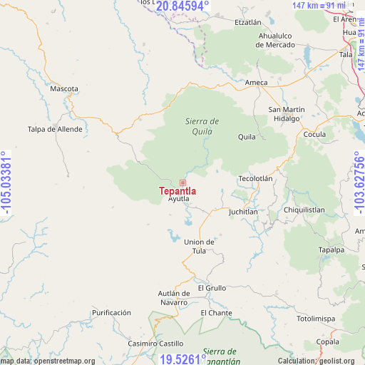
Tepantla GPS coordinates[2]
20° 11' 14.712" North, 104° 19' 50.448" West
| Map corner | latitude | longitude |
|---|---|---|
| Upper-left | 20.84594°, | -105.03381° |
| Center: | 20.18742°, | -104.33068° |
| Lower-right: | 19.5261°, | -103.62756° |
| Map W x H: | 146.8×146.8 km | = 91.2×91.2mi |
| max Lat: | 32.7° ⇑38.9% North |
| Tepantla: | 20.18742° |
| min Lat: | ⇓61.1% South 14.53588° |
| min Long | Tepantla | max Long |
| -117.105° | -104.33068° | -86.73105° |
| W 9.3%⇐ | ⇒90.7% E |
Elevation
Elevation of Tepantla is 1378 m = 4521 ft, and this is 124.3 m = 408 ft above average elevation for this country.
| Max E: |
3497 m = 11473 ft | 51.1% |
| Tepantla | 1378 m 4521 ft | |
| Avg. | 1253.7 m = 4113 ft | |
Min E: |
-1 m = -3 ft | 48.9% |
See also: Mexico elevation on elevation.city.
Geographical zone
Tepantla is located in North Torrid zone (between Equator and Tropic of Cancer). Distance of this Northern Tropic circle is 361.3 km =224.5 mi to North.| Distance of | km | miles | from Tepantla |
|---|---|---|---|
| North Pole | 7762.4 | 4823.3 | to North |
| Arctic Circle | 5156.5 | 3204.1 | to North |
| Tropic Cancer | 361.3 | 224.5 | to North |
| Equator | 2244.6 | 1394.7 | to South |


Nearby cities:
15 places around Tepantla: (largest is in red/bold)
• Atengo
13.7 km =8.5 mi,  45°
45°
• Atenguillo
30.5 km =19 mi,  326°
326°
• Ayutla
6.6 km =4.1 mi,  191°
191°
• Colotitlán
21.1 km =13.1 mi,  118°
118°
• Cuautla
8.2 km =5.1 mi,  280°
280°
• El Salto
24 km =14.9 mi,  312°
312°
• Juanacatlán
8 km =5 mi,  87°
87°
• Juchitlán
26.7 km =16.6 mi, 115°
• Los Volcanes
26.5 km =16.5 mi,  304°
304°
• Mixtlán
29.1 km =18.1 mi,  343°
343°
• San Clemente
14.1 km =8.8 mi,  144°
144°
• Soyatlán del Oro
13.8 km =8.6 mi,  22°
22°
• Tecolotlán
29.6 km =18.4 mi, 86°
• Tenamaxtlán
17.6 km =10.9 mi,  79°
79°
• Unión de Tula
26.5 km =16.5 mi,  165°
165°
Sources, notices
• [Note1] Compared only with cities in Mexico existing in our database
• [Src1] Map data: © OpenStreetMap contributors (CC-BY-SA)
• [Src2] Other city data from geonames.org with taken over terms of usage.
• [Src3] Geographical zone / Annual Mean Temperature by Robert A. Rohde @ Wikipedia
