Atenguillo geodata
Atenguillo (Jalisco) is a seat of a second-order administrative division; located in Mexico in America/Mexico_City (GMT-6) time zone. With population of 1,547 people, there are 5577 cities with bigger population in this country. Compared to other cities in Mexico, 66% of cities are located further ↓South; 90.9% of cities are located further →East and 52.4% of cities have higher elevation than Atenguillo. Note1


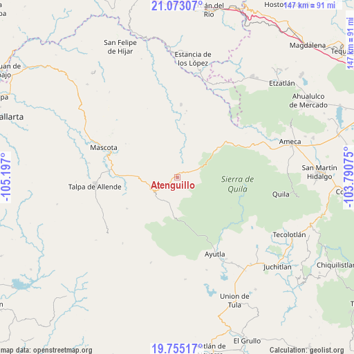
Atenguillo GPS coordinates[2]
20° 24' 55.908" North, 104° 29' 37.932" West
| Map corner | latitude | longitude |
|---|---|---|
| Upper-left | 21.07307°, | -105.197° |
| Center: | 20.41553°, | -104.49387° |
| Lower-right: | 19.75517°, | -103.79075° |
| Map W x H: | 146.5×146.5 km | = 91×91mi |
| max Lat: | 32.7° ⇑34% North |
| Atenguillo: | 20.41553° |
| min Lat: | ⇓66% South 14.53588° |
| min Long | Atenguillo | max Long |
| -117.105° | -104.49387° | -86.73105° |
| W 9.1%⇐ | ⇒90.9% E |
Elevation
Elevation of Atenguillo is 1321 m = 4334 ft, and this is 67.3 m = 221 ft above average elevation for this country.
| Max E: |
3497 m = 11473 ft | 52.4% |
| Atenguillo | 1321 m 4334 ft | |
| Avg. | 1253.7 m = 4113 ft | |
Min E: |
-1 m = -3 ft | 47.6% |
See also: Mexico elevation on elevation.city.
Geographical zone
Atenguillo is located in North Torrid zone (between Equator and Tropic of Cancer). Distance of this Northern Tropic circle is 335.9 km =208.7 mi to North.| Distance of | km | miles | from Atenguillo |
|---|---|---|---|
| North Pole | 7737.1 | 4807.6 | to North |
| Arctic Circle | 5131.2 | 3188.4 | to North |
| Tropic Cancer | 335.9 | 208.7 | to North |
| Equator | 2270 | 1410.5 | to South |


Nearby cities:
15 places around Atenguillo: (largest is in red/bold)
• Atengo
31 km =19.3 mi,  120°
120°
• Ayutla
35.5 km =22.1 mi,  153°
153°
• Cuautla
25.5 km =15.8 mi,  159°
159°
• El Salto
9.2 km =5.7 mi,  183°
183°
• Guachinango
21.5 km =13.4 mi,  33°
33°
• Jayamitla
38.2 km =23.7 mi,  59°
59°
• Juanacatlán
35.3 km =21.9 mi,  134°
134°
• La Laja
19.3 km =12 mi,  349°
349°
• Los Volcanes
11.2 km =7 mi,  204°
204°
• Mascota
33 km =20.5 mi,  291°
291°
• Mixtlán
9.3 km =5.8 mi,  73°
73°
• Ocotes
37.3 km =23.2 mi,  271°
271°
• Soyatlán del Oro
25.6 km =15.9 mi, 119°
• Talpa de Allende
34.4 km =21.4 mi,  263°
263°
• Tepantla
30.5 km =19 mi, 146°
Sources, notices
• [Note1] Compared only with cities in Mexico existing in our database
• [Src1] Map data: © OpenStreetMap contributors (CC-BY-SA)
• [Src2] Other city data from geonames.org with taken over terms of usage.
• [Src3] Geographical zone / Annual Mean Temperature by Robert A. Rohde @ Wikipedia
