Santiago geodata
Santiago (Zacatecas) is a populated place; located in Mexico in America/Mexico_City (GMT-6) time zone. With population of 1,447 people, there are 5963 cities with bigger population in this country. Compared to other cities in Mexico, 86.5% of cities are located further ↓South; 77% of cities are located further →East and 80.1% of cities have lower elevation than Santiago. Note1


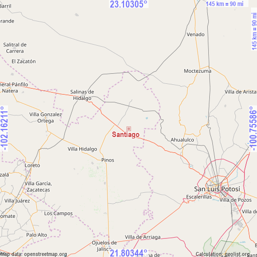
Santiago GPS coordinates[2]
22° 27' 17.172" North, 101° 27' 32.328" West
| Map corner | latitude | longitude |
|---|---|---|
| Upper-left | 23.10305°, | -102.16211° |
| Center: | 22.45477°, | -101.45898° |
| Lower-right: | 21.80344°, | -100.75586° |
| Map W x H: | 144.5×144.5 km | = 89.8×89.8mi |
| max Lat: | 32.7° ⇑13.5% North |
| Santiago: | 22.45477° |
| min Lat: | ⇓86.5% South 14.53588° |
| min Long | Santiago | max Long |
| -117.105° | -101.45898° | -86.73105° |
| W 23%⇐ | ⇒77% E |
Elevation
Elevation of Santiago is 2142 m = 7028 ft, and this is 888.3 m = 2914 ft above average elevation for this country.
| Max E: |
3497 m = 11473 ft | 19.9% |
| Santiago | 2142 m 7028 ft | |
| Avg. | 1253.7 m = 4113 ft | |
Min E: |
-1 m = -3 ft | 80.1% |
See also: Mexico elevation on elevation.city.
Geographical zone
Santiago is located in North Torrid zone (between Equator and Tropic of Cancer). Distance of this Northern Tropic circle is 109.2 km =67.9 mi to North.| Distance of | km | miles | from Santiago |
|---|---|---|---|
| North Pole | 7510.3 | 4666.7 | to North |
| Arctic Circle | 4904.4 | 3047.5 | to North |
| Tropic Cancer | 109.2 | 67.9 | to North |
| Equator | 2496.7 | 1551.4 | to South |


Nearby cities:
15 places around Santiago: (largest is in red/bold)
• Ahijaderos
9.5 km =5.9 mi,  188°
188°
• Caballerías (Caballería Villa Hidalgo)
21.3 km =13.2 mi,  249°
249°
• Encarnación
16.3 km =10.1 mi,  113°
113°
• Espíritu Santo
16.7 km =10.4 mi,  7°
7°
• Guadalupe de los Sauces
10.8 km =6.7 mi,  172°
172°
• La Pendencia
12.2 km =7.6 mi,  261°
261°
• Paso Bonito
24.9 km =15.5 mi,  125°
125°
• Pinos
21.4 km =13.3 mi,  214°
214°
• Saldaña
8.7 km =5.4 mi,  136°
136°
• San Andrés
14.7 km =9.1 mi, 250°
• Santa Ana
7.2 km =4.5 mi, 192°
• Santa Gertrudis
21.8 km =13.5 mi,  42°
42°
• Santa Teresa
17.7 km =11 mi,  115°
115°
• Tolosa
13 km =8.1 mi,  55°
55°
• Trinidad Norte
6 km =3.7 mi,  272°
272°
Sources, notices
• [Note1] Compared only with cities in Mexico existing in our database
• [Src1] Map data: © OpenStreetMap contributors (CC-BY-SA)
• [Src2] Other city data from geonames.org with taken over terms of usage.
• [Src3] Geographical zone / Annual Mean Temperature by Robert A. Rohde @ Wikipedia
